Data and Tools
Texas Forest Info
Find easy-to-use tools, helpful resources, and expert tips to explore, manage, and protect Texas forests.
All Resources on Data and Tools
-
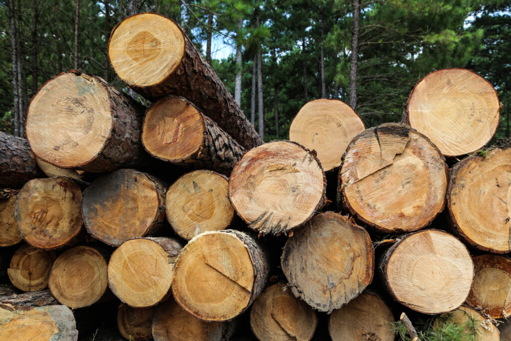
Forest Products Trade 2025
Publication
Explore how Texas’s 2025 forest products trade reflects shifting global markets, highlighting key export and import trends, major trading partners, and the state’s continued importance in the forest products industry. -
Harvest Trends 2024
Publication
The harvest trends report for 2024. -
Texas Timber Price Trends March/April 2026
Publication
The Texas Timber Price Trends Report for March/April 2026. -
Texas A&M Forest Service recently launched Wood Flow South, an interactive website that provides insights into the volume, value and trends of the global forest products trade across the timber supply chain.
-
Texas Timber Price Trends January-February 2026
Data, Publication
The Texas timber price trends report for January through February of 2026. -
An annual summary for 2025 stumpage price trends in Texas.
-
Texas Timber Price Trends Five-Year Price Report 2021–2025
Data, Publication
Stumpage prices for the years 2021-2025. -
Texas Timber Price Trends November-December 2025
Publication
Texas timber price trends for November – December 2025. -
An analysis of Texas’s forest products trade, highlighting market sectors, import-export trends, and the economic impact of the forest products industry.
-
An introduction to Texas Forest Info, a free online tool that helps landowners map property, plan management activities, and connect with forestry professionals.
-
Appraisal of Timberland – Mark Freeman
Publication
An explanation of how timberland is appraised in Texas, outlining eligibility requirements, management plans, and the collaborative appraisal process. -
FY 26 Equipment Round 3 February 13 2026 Funding Summary
Data, Publication
Funding summary FY 26 Equipment round 3 for the Rural Volunteer Fire Department Assistance Program. -
HB3667 Annual Report FY2025
Data, Publication
A FY2025 annual report for the Rural Volunteer Fire Department Insurance Program. -
FY26 TIFMAS Grant Assistance Program Funding Meeting Summary
Data, Publication
A summary of the TIFMAS Grant Assistance Program Funding for the fiscal year of 2026. -
FY2025 HB2604 Annual Report
Data, Publication
An annual report for the Rural Volunteer Fire Department Assistance Program FY2025. -
Training Tuition Guidelines
Publication
Guidelines for training tuition in firefighter training. -
TIFMAS Apparatus Rating Guidelines
Publication
Guidelines for the TIFMAS Apparatus Rating. -
Texas Timber Price Trends September/October 2025
Publication
-
This report details the economic contribution of the Texas Christmas tree industry in 2025.
-
Executive Summary – Voluntary Compliance with Forestry Best Management Practices in East Texas
Publication
An executive summary detailing the voluntary compliance with forestry best management practices in East Texas. -
An implementation report on voluntary compliance with forestry best management practices in East Texas.
-
A 2024 review of the economic contribution of the Texas forest sector.
-
Demonstration of Texas Forest Info
Publication
A write up about the Texas Forest Info and the resources it can provide. -
Timberland Property Tax in Texas (2025)
Publication
A 2025 timberland property tax in Texas workshop. -
Harvest Trends 2022
Publication
Summary of timber harvest volume, value, and production in East Texas, 2022 -
Harvest Trends 2023
Publication
Summary of timber harvest volume, value, and production in East Texas, 2023 -
Texas Potential Prescribed Fire Benefit
Publication
An analysis of land management conditions favorable to prescribed burning. -
An assessment of the economic and environmental risk from wildfire in Texas.
-
Use of Advanced Technology for Record Keeping
Publication
Information about landowner tools and opportunities with use of advanced technology for recordkeeping. -
Texas Timber Price Trends January February 2025
Publication
Texas Timber Price Trends January February 2025 -
Texas Timber Price Trends November December 2024
Publication
Texas Timber Price Trends November December 2024 -
Texas Timber Price Trends 2024 September October
Publication
Texas Timber Price Trends 2024 September October -
Cypress Creek TWS Second Issue 2023
Publication
The Blue Hole in Wimberley, Texas, is a popular swimming spot and regional park that has been preserved since 2003 with sustainable features like rainwater systems. Nearby, Jacob’s Well Natural Area offers hiking, birding, and swimming, with reservations required for access to the spring. -
Cypress Creek TWS First Issue 2023
Publication
The 2022 drought was the worst in Texas since 2011, causing major economic and health problems. As the state’s population grows, water shortages could become a bigger issue, but conservation efforts offer hope for the future. -
Watering Newly Planted Trees
Publication
A guide on how to properly water newly planted trees. -
Vol. XII Forest Landowner Briefings
eLibrary Item
Vol. XII Forest Landowner Briefings -
Forest Landowner Briefings IX
Publication
Forest Landowner Briefings IX -
SPWO Warning 2 Radio PSAs
Publication
SPWO Warning 2 Radio PSAs -
SPWO Warning 1 Radio PSAs
Publication
SPWO Warning 1 Radio PSAs -
PSA audio script Winter Wildfire Weather Warning
Publication
PSA audio script Winter Wildfire Weather Warning -
PSA audio script Winter Fire Weather Warning
Publication
PSA audio script Winter Fire Weather Warning -
Recommended Reading List
Publication
Recommended Reading List -
Hardwood Suitability for and Properties of important Midsouth Soils
-
A Practical Field Method of Site Evaluation for Commercially Important Southern Hardwoods
Publication
A Practical Field Method of Site Evaluation for Commercially Important Southern Hardwoods 1 -
Texas Statewide Assessment of Urban Forests Ecosystem Services
-
Navigating Texas’s Wood Industry Amid Housing Swells
-
Economic Impact of the Texas Forest Sector, 2021
Publication
Economic Impact of the Texas Forest Sector, 2021 -
2020 W-9 Southern Pine Beetle Form
-
FY 2024 Southern Pine Beetle Prevention Program Application
-
Tree Identification Cards
Publication
Tree Identification Cards -
Tree Identification 1-2 Secondary
Tools & Applications
Tree Identification 1-2 Secondary -
Secondary Internet Links
Tools & Applications
Secondary Internet Links for tree trails for educators -
Secondary Cover Tree Trails
Tools & Applications
Secondary Cover Tree Trails -
Urban Forestry
Tools & Applications
Urban Forestry -
All Elementary Modules
Publication
The complete guide of elementary modules for the tree trails for educators -
Five Year Stumpage Prices, 2019-2023
Publication
Five Year Stumpage Prices, 2019-2023 -
Annual Summary Report Timber Price Trends 2023
Publication
Annual Summary Report Timber Price Trends 2023 -
Texas Timber Price Trends November/December 2023
Publication
Texas Timber Price Trends November/December 2023 -
Texas Timber Price Trends September/October 2023
Publication
Texas Timber Price Trends September/October 2023 -
Texas Timber Price Trends July/August 2023
Publication
Texas Timber Price Trends July/August 2023 -
Texas Timber Price Trends May/June 2023
Publication
Texas Timber Price Trends May/June 2023 -
Taxes Timber Price Trends July/August 2024
Publication
Taxes Timber Price Trends July/August 2024 -
Texas Timber Price Trends May/June 2024
Publication
Texas Timber Price Trends May/June 2024 -
Texas Timber Price Trends March/April 2024
Publication
Texas Timber Price Trends March/April 2024 -
Texas Timber Price Trends January/February 2024
Publication
Texas Timber Price Trends January/February 2024 -
The Community Greening Grant Application Worksheet
-
The Tree Planting Grant Application Worksheet
-
The Workforce Development Grant Application Worksheet
-
The Municipal Forester Grant Application Worksheet
-
The Human Health Equity and Accessibility Grant Application Worksheet
-
A work shade for the climate resilience application
-
The TPWD Private Lands RX Fire Briefing Outline
-
The Annual Timber Price Trends Report 2024
-
Texas Wildland Fire Preparedness Levels
Publication
-
Stewardship Values
Tools & Applications
Explore the added financial and environmental benefits of land management through our stewardship values dashboard. -
Chinese Tallow Story Map
Tools & Applications
Tour this story map to learn more about Chinese tallow identification, ecology, ecological threat, distribution, invasion potential, and treatment options in Texas. -
Texas Tree ID
Tools & Applications
The Texas Tree ID website helps users identify Texas trees by providing detailed information on tree species, including photos, characteristics, and distribution maps. Easily browse or search to find trees native to Texas and learn more about their unique traits. -
Texas Forest Carbon Clock
Tools & Applications
Texas Forest Carbon Clock displays the real-time tons of carbon captured from the atmosphere and stored in Texas forests. -
Shaded Re-LEAF in the Rio Grande Valley
Tools & Applications
The Shaded ReLeaf Dashboard helps Rio Grande Valley communities most impacted by excessive heat. It combines geospatial satellite data, Social Vulnerability Index, and tree canopy info to guide strategic, high-impact tree planting initiatives. -
Healthy Trees, Healthy Lives Geospatial Viewer
Tools & Applications
Healthy Trees, Healthy Lives uses research to guide tree planting for better mental and physical health. Trees enhance well-being through tree-lined streets, treescapes near schools and medical facilities, and nearby greenspaces. -
Got Land?
Tools & Applications
This app is a support tool that assists potential or new landowners during the initial stages of acquiring or owning property by providing management information and resources based on property goals selected. -
Funding Connector
Tools & Applications
Funding Connector serves as a clearinghouse for information about various natural resource programs that offer financial assistance to Texas landowners, communities, and nonprofit organizations to implement conservation practices. -
Forest Action Plan Data Explorer
Tools & Applications
The Texas Forest Action Plan is the state’s plan to make sure that Texas forest resources are effectively managed and conserved. You can explore the data behind the plan in our Forest Action Plan Data Explorer. -
Draw My Ranch
Tools & Applications
Designed to create ranch planning reports, Draw My Ranch simplifies property mapping and enhances wildfire preparedness. You can define your property’s boundaries, roads, fences, and other features with intuitive drawing tools and compile information into a customized report. -
One of the first steps in managing urban forests is to know what’s in it. Where are trees located? What are their condition, size, and species? All questions that can be answered by conducting an inventory. An essential tool for developing an urban forest management plan. There is no single, correct way of conducting an […]
-
Forecast Fire Danger
Tools & Applications
A product depicting expected future fire danger based on National Weather Service weather forecasts. -
Famous Trees of Texas
Tools & Applications
If Texas’ trees could speak, what stories they would tell—stories of love, honor, mystery, justice, and injustice. Famous Trees of Texas, the state’s historic tree program, is an elite group of trees that have witnessed exciting events in Texas’ frontier history. Tour the trees through our Story Map, and learn more about Texas history. -
My Land Management Connector
Tools & Applications
Helps landowners find land management service providers, assists service providers in aggregating land management services, and works for any size property. -
Trees Count
Tools & Applications
A mobile app for iOS and Android that allows users to inventory and map trees, generate reports, and transfer data across devices. Features iTree compatibility and exports data to CSV files for use in Excel. -
Texas Forestry BMPs
Tools & Applications
The Texas Forestry BMPs app is based on the Texas Forestry Best Management Practices Handbook publication, often referred to as the “Blue Book”, the state manual for protecting water quality during forest operations. -
Plan My Land Operation
Tools & Applications
Plan My Land Operation allows you to make a map of your property while taking a deeper dive into operational considerations as you manage your land. You can identify sensitive areas, determine soil suitability, create elevation profiles, and calculate recommended culvert size. -
Urban Tree Canopy
Tools & Applications
Displays predicted urban growth areas, urban tree canopy (UTC) for selected communities, and models future UTC based on management policy. -
Tree Risk
Tools & Applications
Helps users maps trees with obvious defects that have a probable or imminent likelihood of failure and identifies treatment. It guides through identifying hazards, helping protect communities mitigate tree-related damage. -
Tree Trails
Tools & Applications
Tree Trails is a conservation education project that enhances outdoor classrooms at schools, nature centers, and public parks by creating educational trails centered around trees, promoting environmental awareness, and learning through nature. -
Forest Distribution
Tools & Applications
Displays the various types of trees statewide and provides an estimate of the amount of biomass that occurs within 50, 75, and 100 miles of a user-defined location. -
My City’s Trees
Tools & Applications
The My City’s Trees application enables anyone to access Urban FIA Data and produce custom analyses and reports. -
Texas Tree Planting Guide
Tools & Applications
The Texas Tree Planting website offers resources and guidance on tree planting in Texas, including best practices, species recommendations, and site selection tips. Learn how to successfully plant and care for trees to improve your landscape. -
Forest Legacy
Tools & Applications
Texas is under threat of losing much of its working forests to non-forest uses. Learn more about the ecologically important forests protected by the Forest Legacy Program in this story map. -
Tree Ordinances
Tools & Applications
The Model Public Tree Ordinance tutorial helps cities create effective public tree ordinances to achieve Tree City USA status. Download a fillable public tree care ordinance document to get started on enhancing urban tree management. -
Bastrop – A Story of Wildfire and Restoration
Tools & Applications
Tour through the story of Bastrop wildfire, restoration, and more with interactive maps and compelling multimedia content. -
Map My Property
Tools & Applications
Map My Property provides landowners and other interested users a quick and simple tool for making a map of their property that can be shared with others. It also provides a variety of historical imagery and other mapped data for context. -
Texas Forest Information Portal
Tools & Applications
The Texas Forest Information Portal is the one-stop shop for everything related to trees and forests in Texas. This interactive, spatially based platform is designed for landowners, communities, professionals, and the general public to find useful insights into Texas forest resources. -
Timberland Decision Support System
Tools & Applications
The Timberland Decision Support System is a web-based decision support tool for non-industrial private landowners and others who are interested in timberland investment and management. -
Forest Drought
Tools & Applications
The Forest Drought application allows users to explore past, current, and future drought conditions on Texas forestland, bringing together data from the U.S. Drought Monitor, NOAA, and Texas A&M Forest Service. You can create a custom report to save or share. -
Timber Supply Analysis
Tools & Applications
The Timber Supply Analysis website provides estimates of timberland area and standing timber, growth, and removals within a user-defined area in the U.S. South. -
Forest Products Directory
Tools & Applications
Provides information on the various forest products industries in Texas and searchable by several attributes. -
Guide for media use when disseminating information related to fire
-
Wildfire weather terms
Publication
Terms related to fire weather -
Guidelines for Geocaching on Texas State Forests
Publication
Guidelines for Geocaching permits, locations, containers and content -
Fairchild State Forest Trail Map
Publication
Map of the I.D. Fairchild State Forest in Cherokee County; includes roads and trails -
Siecke State Forest Trail Map
Publication
Map of the E.O. Siecke State Forest in Newton County; includes roads and trails -
Masterson State Forest Trail Map
Publication
Map of the Masterson State Forest in Jasper, Texas -
John Henry Kirby State Forest
Publication
Map of the John Henry Kirby State Forest in Tyler County, Texas -
Project Learning Tree correlations with Tree Trails curriculum
-
Project Field Test with Teachers
Publication
Report on project field test of Tree Trails with teachers -
Tree Search
Publication
Tree Search activity – find all the listed trees -
Lesson only for Tree Trails secondary lesson 3, “Benefits and Values”
-
All handouts needed for Tree Trails secondary lesson 4, “Student Service Leader”
-
All handouts needed for Tree Trails secondary lesson 2-2, “Ecological Diversity and Native Species”
-
All handouts needed for Tree Trails secondary lesson 2-3, “Tree and Forest Health”
-
Secondary Lesson Cover
Publication
Tree Trails cover page for secondary lessons -
Internet Links
Publication
Internet links for Tree Trails secondary lessons -
All handouts needed for Tree Trails secondary lesson 1-1, “Map a Tree Trail”
-
All handouts needed for Tree Trails secondary lesson 1-2, “Tree Identification”
-
All handouts needed for Tree Trails secondary lesson 1-3, “Tree Measurement”
-
All handouts needed for Tree Trails secondary lesson 2-1, “Tree Structure and Function”
-
Tree Trails Elementary Lesson 8: Tree History
Publication
Tree Trails elementary lesson 8, “Tree History” -
Tree Trails Elementary Lesson 9: Urban Forestry
Publication
Tree Trails elementary lesson 9, “Urban Forestry” -
All handouts needed for Tree Trails elementary lesson 10, “Student Service Leader”
-
Career Cards
Publication
Career cards for Tree Trails elementary lesson 10, “Student Service Leader” -
Student Service Leader Certificate
Publication
Sample certificate of achievement for Tree Trails elementary lesson 10, “Student Service Leader” -
All handouts needed for Tree Trails elementary lesson 7, “Tree and Forest Health”
-
All handouts needed for Tree Trails elementary lesson 4, “Tree Structure and Function”
-
All handouts needed for Tree Trails elementary lesson 5, “Benefits and Values of Trees”
-
All handouts needed for Tree Trails elementary lesson 6, “Diversity of Species and Ecosystems”
-
Tree Trails Data Sheet (fillable pdf)
Publication
Fillable PDF data sheet you can use to record Tree Trails data for elementary lesson 1 and secondary lesson 1-1, “Map a Tree Trail” -
All handouts needed for Tree Trails elementary lesson 2, “Tree Identification”
-
Sample Leaf Cards
Publication
Sample leaf cards for Tree Trails elementary lesson 2 and secondary lesson 1-2, “Tree Identification” -
All handouts needed for Tree Trails elementary lesson 3, “Tree Measurement”
-
All Elementary Lesson Modules Package
Publication
All Tree Trails elementary lesson modules in one file -
Elementary Content Area TEKS – Grade 5
Publication
Tree Trails – Texas Essential Knowledge and Skills for 5th Grade -
All handouts needed for Tree Trails elementary lesson 1, “Map a Tree Trail”
-
All Practice Key handouts
Publication
All the handouts needed for the dichotomous key practice activity in one file -
Tree Trails Flyer
Publication
Flyer about Tree Trails conservation education resource -
Tree Trails Overview
Publication
Overview about Tree Trails conservation education resource -
Tree Trails Quick Start
Publication
Quick start guide for using Tree Trails -
Service Leader Sample Projects
Publication
Tree Trails service project ideas -
Tree Measurement Guidelines
Publication
Tree Trails guidelines for measuring tree circumference, height, and crown spread -
Annual Benefits
Publication
Tree Trails overview of benefits provided by trees -
Tree Trails – Tree Tag
Publication
Tree Trails tree tag you can fill out and hang on a tree to show its benefits -
Virtual tour of BMP demonstrations on the W.G. Jones State Forest
-
Round 5 Executive Summary
Publication
Highlights from the fifth round (2002) of BMP Implementation Monitoring in Texas -
Round 6 Executive Summary
Publication
Highlights from the sixth round (2005) of BMP Implementation Monitoring in Texas -
Round 7 Executive Summary
Publication
Highlights from the seventh round (2008) of BMP Implementation Monitoring in Texas -
Round 8 Executive Summary
Publication
Highlights from the eighth round (2011) of BMP Implementation Monitoring in Texas -
Round 1 — Voluntary Implementation with Forestry Best Management Practices in East Texas
Publication
Results from the first round (1992) of BMP Implementation Monitoring in Texas -
Round 1 Executive Summary
Publication
Highlights from the first round (1992) of BMP Implementation Monitoring in Texas -
Round 2 — Voluntary Implementation with Forestry Best Management Practices in East Texas (1996)
Publication
Results from the second round (1996) of BMP Implementation Monitoring in Texas -
Round 2 Executive Summary
Publication
Highlights from the second round (1996) of BMP Implementation Monitoring in Texas -
Round 3 — Voluntary Implementation with Forestry Best Management Practices in East Texas (1998)
Publication
Results from the third round (1998) of BMP Implementation Monitoring in Texas -
Round 3 Executive Summary
Publication
Highlights from the third round (1998) of BMP Implementation Monitoring in Texas -
Round 4 — Voluntary Implementation with Forestry Best Management Practices in East Texas (2000)
Publication
Results from the fourth round (2000) of BMP Implementation Monitoring in Texas -
Information sheet on price ranges for common forest management practices
-
Analysis of urban forest benefits and tree canopy
-
Austin’s Urban Forest Plan
Publication
City of Austin Master Plan for urban forests and trees on public property -
Summary of mesquite wood properties
-
Describes the instruction for submitting information or evidence to chief appraiser for timberland appraisal
-
Thousands across the Texas Panhandle received wireless emergency alerts Feb. 26 and 27, warning of an eminent, dangerous wildfire on the landscape with the potential to expand.
-
Hurricane Beryl Map
Publication
Hurricane Beryl Map -
Economic Contribution of the Texas Christmas Tree Industry, 2023
-
Impacts of Hurricane Harvey on Houston’s Urban Forest
-
Texas A&M Forest Service and the Texas Longleaf Team have funding available through the Texas Longleaf Conservation Assistance Program for landowners interested in restoring and enhancing longleaf pine ecosystems on their property.
-
Famous Trees of Texas – Crossroads
News Story
Throughout history these trees have been used as a marker to pave the way for paths across Texas. -
Texas Timber Price Trends March/April 2023
Publication
Information on bi-monthly average price for pine sawlogs, pulpwood, chip-n-saw, hardwood sawlog, and hardwood pulpwood in East Texas -
Texas Timber Price Trends January/February 2023
Publication
Information on bi-monthly average price for pine sawlogs, pulpwood, chip-n-saw, hardwood sawlog, and hardwood pulpwood in East Texas -
Texas Timber Price Trends November/December 2022
Publication
Information on bi-monthly average price for pine sawlogs, pulpwood, chip-n-saw, hardwood sawlog, and hardwood pulpwood in East Texas -
Annual Summary Report Timber Price Trends 2022
Publication
Information on annual average price for pine sawlogs, pulpwood, chip-n-saw, hardwood sawlog, and hardwood pulpwood in East Texas -
City of Austin Ice Storm Damage Assessment
Publication
City of Austin Ice Storm Damage Assessment -
Texas Timber Price Trends September/October 2022
Publication
Information on bi-monthly average price for pine sawlogs, pulpwood, chip-n-saw, hardwood sawlog, and hardwood pulpwood in East Texas -
Texas Timber Price Trends July/August 2022
Publication
Information on bi-monthly average price for pine sawlogs, pulpwood, chip-n-saw, hardwood sawlog, and hardwood pulpwood in East Texas -
Texas Timber Price Trends May/June 2022
Publication
Information on bi-monthly average price for pine sawlogs, pulpwood, chip-n-saw, hardwood sawlog, and hardwood pulpwood in East Texas -
5-Year Stumpage Prices, 2017-2021
Publication
Information on 5-year average price for pine sawlogs, pulpwood, chip-n-saw, hardwood sawlog, and hardwood pulpwood in East Texas -
Texas Timber Price Trends March/April 2022
Publication
Information on bi-monthly average price for pine sawlogs, pulpwood, chip-n-saw, hardwood sawlog, and hardwood pulpwood in East Texas -
Comprehensive analysis of services provided by Texas urban and community forests
-
Texas Timber Price Trends January/February 2022
Publication
Information on bi-monthly average price for pine sawlogs, pulpwood, chip-n-saw, hardwood sawlog, and hardwood pulpwood in East Texas -
Annual Summary Report Timber Price Trends 2021
Publication
Information on annual average price for pine sawlogs, pulpwood, chip-n-saw, hardwood sawlog, and hardwood pulpwood in East Texas -
Texas Timber Price Trends November/December 2021
Publication
Information on bi-monthly average price for pine sawlogs, pulpwood, chip-n-saw, hardwood sawlog, and hardwood pulpwood in East Texas -
Timber Damage Assessment for the Northeast Texas Tornadoes of November 4, 2022
-
Texas Timber Price Trends September/October 2021
Publication
Information on bi-monthly average price for pine sawlogs, pulpwood, chip-n-saw, hardwood sawlog, and hardwood pulpwood in East Texas -
Texas Timber Price Trends July/August 2021
Publication
Information on bi-monthly average price for pine sawlogs, pulpwood, chip-n-saw, hardwood sawlog, and hardwood pulpwood in East Texas -
Texas Timber Price Trends May/June 2021
Publication
Information on bi-monthly average price for pine sawlogs, pulpwood, chip-n-saw, hardwood sawlog, and hardwood pulpwood in East Texas -
Texas Timber Price Trends March/April 2021
Publication
Information on bi-monthly average price for pine sawlogs, pulpwood, chip-n-saw, hardwood sawlog, and hardwood pulpwood in East Texas -
Analysis of lumber and timber prices trends during the COVID-19 pandemic
-
Texas Timber Price Trends January/February 2021
Publication
Information on bi-monthly average price for pine sawlogs, pulpwood, chip-n-saw, hardwood sawlog, and hardwood pulpwood in East Texas -
Harvest Trends 2019
Publication
Summary of timber harvest volume and value, and production in East Texas, 2019 -
Annual Summary Report Timber Price Trends 2020
Publication
Information on annual average price for pine sawlogs, pulpwood, chip-n-saw, hardwood sawlog, and hardwood pulpwood in East Texas -
Texas Timber Price Trends November/December 2020
Publication
Information on bi-monthly average price for pine sawlogs, pulpwood, chip-n-saw, hardwood sawlog, and hardwood pulpwood in East Texas -
Analysis of the economic contribution of the Christmas tree industry in Texas, 2020
-
Texas Timber Price Trends September/October 2020
Publication
Information on bi-monthly average price for pine sawlogs, pulpwood, chip-n-saw, hardwood sawlog, and hardwood pulpwood in East Texas -
Coastal Forest Restoration Maps
Publication
Maps using Forest Inventory & Analysis data to show status and disturbance as part of “Restoring the Coastal Forests of Texas” project -
Restoring the Coastal Forests of Texas
Tools & Applications
Interactive story map with information on disturbance impacts and how to manage forests threatened by disasters such as hurricanes. -
Longleaf Pine in East Texas, 2019
Publication
Maps of FIA plots showing longleaf pine status and history in East Texas through 2019 -
Shortleaf Pine in East Texas, 2019
Publication
Maps of FIA plots showing shortleaf pine status and history in East Texas through 2019 -
Texas A&M Forest Service launched an application today to help users quickly identify the root of a tree’s problem, whether it be caused by insects, diseases or other factors.
-
Texas Timber Price Trends July/August 2020
Publication
Information on bi-monthly average price for pine sawlogs, pulpwood, chip-n-saw, hardwood sawlog, and hardwood pulpwood in East Texas -
My Tree ID Mobile App
Tools & Applications
My Tree ID helps identify tree species based on leaves, flowers, seed, bark or location using a key, descriptions, and full-color images. -
Texas Timber Price Trends May/June 2020
Publication
Information on bi-monthly average price for pine sawlogs, pulpwood, chip-n-saw, hardwood sawlog, and hardwood pulpwood in East Texas -
TreeMD
Tools & Applications
Find the root of your tree’s problem whether it be caused by insect, disease or other factor. TreeMD’s main feature is a diagnosis tool that allows you to quickly find results from its vast database. -
Texas Timber Price Trends March/April 2020
Publication
Information on bi-monthly average price for pine sawlogs, pulpwood, chip-n-saw, hardwood sawlog, and hardwood pulpwood in East Texas -
Texas A&M Forest Service podcast, “Trees Are Key”, is reminding listeners to get outside and explore during stay-at-home times. Celebrating five years this spring, the short, weekly podcast helps listeners better care for their trees by featuring short lessons and weekly tree highlights.
-
Texas Oak Wilt
Tools & Applications
Explore resources for managing oak wilt in Texas. -
Polk County Tornado Damage Severity
Publication
Map showing track and damage of Polk County Tornado in April 2020 -
Polk County Tornado Timber Damage Assessment
Publication
Rapid assessment of timber damage caused by the Polk County tornado in April 2020 -
Five Year stumpage prices 2015-2019
Publication
Information on 5-year average price for pine sawlogs, pulpwood, chip-n-saw, hardwood sawlog, and hardwood pulpwood in East Texas -
Big Tree Registry
Tools & Applications
The Big Tree Registry is a list of the largest known specimens of each Texas tree species. This application displays tree measurements and photos as well as public tree locations. -
Texas Timber Price Trends January/February 2020
Publication
Information on bi-monthly average price for pine sawlogs, pulpwood, chip-n-saw, hardwood sawlog, and hardwood pulpwood in East Texas -
Annual Summary Report Timber Price Trends 2019
Publication
Information on annual average price for pine sawlogs, pulpwood, chip-n-saw, hardwood sawlog, and hardwood pulpwood in East Texas -
Harvest Trends 2018
Publication
Summary of timber harvest volume and value, and production in East Texas, 2018 -
Texas Timber Price Trends November/December 2019
Publication
Information on bi-monthly average price for pine sawlogs, pulpwood, chip-n-saw, hardwood sawlog, and hardwood pulpwood in East Texas -
Texans are using prescribed fire more than ever to manage land and mitigate wildfires. Now there is data to support this. A recent statewide survey found that 402,017 acres were treated with prescribed fire in Texas during 2018.
-
Forest Action Plan, 2020
Publication
The 2020 Texas Forest Action Plan. A comprehensive analysis of forest-related conditions, trends, threats, and opportunities in Texas and a strategy to address them. -
BMP Implementation Monitoring
Tools & Applications
A story map summarizing the BMP Implementation Monitoring Program’s 10th round in 2018. -
A Story on Managing Hardwoods in East Texas
Tools & Applications
Story map highlighting challenges and benefits of managing hardwood forests -
Hardwood Management Priority Regions
Publication
Regions at highest risk of catastrophic loss of hardwoods -
Maps of FIA plots showing hardwood stocking history, 2006-2016, in East Texas on all hardwood forest types
-
Maps of FIA plots showing hardwood stocking history, 2006-2016, in East Texas on oak-hickory forest types
-
Maps of FIA plots showing hardwood stocking history, 2006-2016, in East Texas on oak-pine forest types
-
Maps of FIA plots showing hardwood stocking history, 2006-2016, in East Texas on oak-gum-cypress forest types
-
Maps of FIA plots showing hardwood stocking history, 2006-2016, in East Texas on elm-ash-cottonwood forest types
-
Maps of FIA plots showing hardwood stocking history, 2006-2016, in East Texas on exotic hardwood forest types
-
Maps of FIA plots showing hardwood stocking history, 2006-2016, in East Texas on various hardwood forest types
-
Maps of FIA plots showing hardwood mortality history (volume), 2006-2016, in East Texas on all forest types
-
Maps of FIA plots showing hardwood mortality history (volume), 2006-2016, in East Texas on all hardwood forest types
-
Maps of FIA plots showing hardwood mortality history (volume), 2006-2016, in East Texas on oak-hickory forest types
-
Maps of FIA plots showing hardwood mortality history (volume), 2006-2016, in East Texas on oak-pine forest types
-
Maps of FIA plots showing hardwood mortality history (volume), 2006-2016, in East Texas on oak-gum-cypress forest types
-
Maps of FIA plots showing hardwood mortality history (volume), 2006-2016, in East Texas on elm-ash-cottonwood forest types
-
Maps of FIA plots showing hardwood mortality history (volume), 2006-2016, in East Texas on exotic hardwood forest types
-
Maps of FIA plots showing hardwood mortality history (volume), 2006-2016, in East Texas on various forest types
-
Maps of FIA plots showing hardwood mortality history (trees), 2006-2016, in East Texas on all forest types
-
Maps of FIA plots showing hardwood mortality history (trees), 2006-2016, in East Texas on all hardwood forest types
-
Maps of FIA plots showing hardwood mortality history (trees), 2006-2016, in East Texas on oak-hickory forest types
-
Maps of FIA plots showing hardwood mortality history (trees), 2006-2016, in East Texas on oak-pine forest types
-
Maps of FIA plots showing hardwood mortality history (trees), 2006-2016, in East Texas on oak-gum-cypress forest types
-
Maps of FIA plots showing hardwood mortality history (trees), 2006-2016, in East Texas on elm-ash-cottonwood forest types
-
Maps of FIA plots showing hardwood mortality history (trees), 2006-2016, in East Texas on exotic hardwood forest types
-
Maps of FIA plots showing hardwood mortality history (trees), 2006-2016, in East Texas on various forest types
-
Texas Timber Price Trends September/October 2019
Publication
Information on bi-monthly average price for pine sawlogs, pulpwood, chip-n-saw, hardwood sawlog, and hardwood pulpwood in East Texas -
Texas Scenic Views
Tools & Applications
Texas Scenic Views shows you where you can find exceptional displays of fall color and spring blooms throughout Texas. You can see current ratings as well as post your own comments and ratings and contribute suggestions. -
Texas Timber Price Trends May/June 2019
Publication
Information on bi-monthly average price for pine sawlogs, pulpwood, chip-n-saw, hardwood sawlog, and hardwood pulpwood in East Texas -
Texas Timber Price Trends July/August 2019
Publication
Information on bi-monthly average price for pine sawlogs, pulpwood, chip-n-saw, hardwood sawlog, and hardwood pulpwood in East Texas -
Forestry officials from across the United States unveiled a new web application this week that will help communities, investors and wood buyers determine the supply of available forest resources in a given area and make more informed decisions on where to locate wood-based businesses in the U.S. South.
-
Forest and Drinking Water Connection
Tools & Applications
Story map that highlights the forest and water relationship, priority watersheds for surface drinking water supplies, and how the forest and water sectors are partnering to sustain these vital resources. -
Texas Timber Price Trends March/April 2019
Publication
Information on bi-monthly average price for pine sawlogs, pulpwood, chip-n-saw, hardwood sawlog, and hardwood pulpwood in East Texas -
Economic Impact of Urban Forests in Texas
Publication
Evaluation of economic impact of urban forests in Texas. -
Forest Herbicide Prescriptions
Tools & Applications
Forest Herbicide Prescriptions is a tool for finding the best silvicultural herbicide prescription to match your need. -
Texas Timber Price Trends January/February 2019
Publication
Information on bi-monthly average price for pine sawlogs, pulpwood, chip-n-saw, hardwood sawlog, and hardwood pulpwood in East Texas -
Annual Summary Report Timber Price Trends 2018
Publication
Information on annual average price for pine sawlogs, pulpwood, chip-n-saw, hardwood sawlog, and hardwood pulpwood in East Texas -
Texas Timber Price Trends November/December 2018
Publication
Information on bi-monthly average price for pine sawlogs, pulpwood, chip-n-saw, hardwood sawlog, and hardwood pulpwood in East Texas -
Harvest Trends 2017
Publication
Summary of timber harvest volume and value, and production in East Texas, 2017 -
Economic Contributions of Urban Forests in Texas
Publication
Report on the economic contribution of the urban & community forest industry in Texas -
Round 10 – Voluntary Implementation with Forestry Best Management Practices in East Texas (2018)
Publication
Results from the tenth round (2018) of BMP Implementation Monitoring in Texas. -
Round 10 Executive Summary
Publication
Highlights from the tenth round (2018) of BMP Implementation Monitoring in Texas. -
Texas Timber Price Trends September/October 2018
Publication
Information on bi-monthly average price for pine sawlogs, pulpwood, chip-n-saw, hardwood sawlog, and hardwood pulpwood in East Texas -
Cross Laminated Timber (CLT) Talking Points
Publication
Description of cross laminated timber (CLT) and its benefits and limitations as a building material. -
Texas Timber Price Trends July/August 2018
Publication
Information on bi-monthly average price for pine sawlogs, pulpwood, chip-n-saw, hardwood sawlog, and hardwood pulpwood in East Texas -
$471,650 in grant funds available for prescribed burning. Some Texas landowners may be eligible for funding to help with prescribed burning costs on private lands. Now through Sept. 28, 2018, Texas A&M Forest Service is accepting grant applications to cover
-
Softwood Lumber Prices Hit Record Levels
Publication
Article exploring factors that influence lumber prices following record high softwood lumber prices in 2018 -
Esri, the global leader in spatial analytics, presented Texas A&M Forest Service with their Special Achievement in GIS (SAG) Award on July 11 at the annual Esri User Conference. Selected from over 300,000 eligible candidates, Texas A&M Forest Service
-
Texas Timber Price Trends May/June 2018
Publication
Information on bi-monthly average price for pine sawlogs, pulpwood, chip-n-saw, hardwood sawlog, and hardwood pulpwood in East Texas -
Texas Timber Price Trends March/April 2018
Publication
Information on bi-monthly average price for pine sawlogs, pulpwood, chip-n-saw, hardwood sawlog, and hardwood pulpwood in East Texas -
Geocaching
Tools & Applications
Geocaching is an outdoor treasure hunt using GPS-enabled devices. Explore the app to discover geocaches at different Texas A&M Forest Service offices throughout Texas. -
Discover Trees and Woody Plants
Tools & Applications
Discover the trees and woody plants of Texas A&M University’s Research Park and George Bush Library areas in College Station with this visual guide. The guide lists over 35 species with one or more photos and a brief description. -
Annual Summary Report Timber Price Trends 2017
Publication
Information on annual average price for pine sawlogs, pulpwood, chip-n-saw, hardwood sawlog, and hardwood pulpwood in East Texas -
Texas Timber Price Trends January/February 2018
Publication
Information on bi-monthly average price for pine sawlogs, pulpwood, chip-n-saw, hardwood sawlog, and hardwood pulpwood in East Texas -
Five Year stumpage prices 2013-2017
Publication
Information on 5-year average price for pine sawlogs, pulpwood, chip-n-saw, hardwood sawlog, and hardwood pulpwood in East Texas -
Information on woodland area, ownership, forest types, biomass, and more in Central and West Texas
-
Information on woodland area, ownership, forest types, biomass, and more in Central and West Texas
-
Application for assistance through FEFP
-
Application for Risk Pool insurance
-
Texas Timber Price Trends November/December 2017
Publication
Information on bi-monthly average price for pine sawlogs, pulpwood, chip-n-saw, hardwood sawlog, and hardwood pulpwood in East Texas -
Harvest Trends 2016
Publication
Summary of timber harvest volume and value, and production in East Texas, 2016 -
Statewide Summary of Potential Impacts of EAB
Publication
Fact sheet on the potential impacts of a statewide infestation Emerald Ash Borer -
Texas Timber Price Trends September/October 2017
Publication
Information on bi-monthly average price for pine sawlogs, pulpwood, chip-n-saw, hardwood sawlog, and hardwood pulpwood in East Texas -
Fact sheet on the potential impacts of Emerald Ash Borer infestation in the DFW metro area
-
Fact sheet on the potential impacts of Emerald Ash Borer infestation in the Austin/San Antonio area
-
Fact sheet on the potential impacts of Emerald Ash Borer infestation in the Houston metro area
-
Fact sheet on the potential impacts of Emerald Ash Borer infestation in West Texas communities
-
Texas Timber Price Trends July/August 2017
Publication
Information on bi-monthly average price for pine sawlogs, pulpwood, chip-n-saw, hardwood sawlog, and hardwood pulpwood in East Texas -
Economic Impact of the Texas Forest Sector, 2015
Publication
Report on the economic impact of the forest sector in East Texas using 2015 IMPLAN data -
Technical guidelines to protect soil and water resources during forest management operations
-
Texas Timber Price Trends May/June 2017
Publication
Information on bi-monthly average price for pine sawlogs, pulpwood, chip-n-saw, hardwood sawlog, and hardwood pulpwood in East Texas -
Counting on Houston’s trees
News Story
The largest city in the largest continental state in America has an urban forest to match. And now, for the first time, information about Houston’s trees is available online. The My City’s Trees web application is a free tool that makes community tree data easily accessible to the public. -
Jones State Forest Trail Map
Publication
William Goodrich Jones State Forest public use map -
Texas Timber Price Trends March/April 2017
Publication
Information on bi-monthly average price for pine sawlogs, pulpwood, chip-n-saw, hardwood sawlog, and hardwood pulpwood in East Texas -
Lacy-Lakeview Fire Department received a $7,700 grant for the purchase of a forcible-entry training door. The funding was through Texas A&M Forest Service’s Rural Volunteer Fire Department Assistant Program. “The forcible-entry training system will allow our volunteers to experience the proper technique on how to utilize the tools we have with less injuries to the […]
-
Annual Summary Report Timber Price Trends 2016
Publication
Information on annual average price for pine sawlogs, pulpwood, chip-n-saw, hardwood sawlog, and hardwood pulpwood in East Texas -
In preparation for the 2017 wildfire season, firefighters from across the state are set to attend a wildfire academy at Camp Bowie in Brownwood. The 16th Annual Central Texas Wildfire Academy will take place Feb. 22 – 26 and
-
Texas Timber Price Trends January/February 2017
Publication
Information on bi-monthly average price for pine sawlogs, pulpwood, chip-n-saw, hardwood sawlog, and hardwood pulpwood in East Texas -
East Texas Forestlands, 2015 (Report)
Publication
Information on timberland area, ownership, forest types, timber volume, and more in East Texas -
East Texas Forestlands, 2015 (Appendix)
Publication
Information on timberland area, ownership, forest types, timber volume, and more in East Texas -
Information on woodland area, ownership, forest types, biomass, and more in Central and West Texas
-
Information on woodland area, ownership, forest types, biomass, and more in Central and West Texas
-
Harvest Trends 2015
Publication
Summary of timber harvest volume and value, and production in East Texas, 2015 -
Operation Ponderosa one-pager
Publication
Information on restoration and recovery efforts for ponderosa pines in the Davis Mountains -
2017 NFP Grant Summary
Publication
2017 national fire plan grant summary -
Economic Impact
Tools & Applications
Economic Impact is a web-based interactive tool to summarize economic impacts of the forest sector in East Texas. You can also access statewide economic information. -
Texas Timber Price Trends November/December 2016
Publication
Information on bi-monthly average price for pine sawlogs, pulpwood, chip-n-saw, hardwood sawlog, and hardwood pulpwood in East Texas -
Texas Timber Price Trends September/October 2016
Publication
Information on bi-monthly average price for pine sawlogs, pulpwood, chip-n-saw, hardwood sawlog, and hardwood pulpwood in East Texas -
Texas Timber Price Trends July/August 2016
Publication
Information on bi-monthly average price for pine sawlogs, pulpwood, chip-n-saw, hardwood sawlog, and hardwood pulpwood in East Texas -
Texas State Forests and Arboretums Story Map
Tools & Applications
Tour through the state forests and arboretums managed by Texas A&M Forest Service that serve as educational resources for Texans and visitors. -
Austin trees – there’s an app for that
News Story
For the first time ever, a census for trees is available in a new, easy-to-use application developed by Texas A&M Forest Service. -
Texas Timber Price Trends May/June 2016
Publication
Information on bi-monthly average price for pine sawlogs, pulpwood, chip-n-saw, hardwood sawlog, and hardwood pulpwood in East Texas -
Texas Timber Price Trends March/April 2016
Publication
Information on bi-monthly average price for pine sawlogs, pulpwood, chip-n-saw, hardwood sawlog, and hardwood pulpwood in East Texas -
Annual Summary Report Timber Price Trends 2015
Publication
Information on annual average price for pine sawlogs, pulpwood, chip-n-saw, hardwood sawlog, and hardwood pulpwood in East Texas -
Want to learn how your community can manage a wildfire incident? The newest learning tool in wildland fire and all-hazard management is set to be showcased at Lone Star College-Montgomery in the Woodlands. Simtable uses geographic data and a variety of colorful and interact
-
Texas Timber Price Trends January/February 2016
Publication
Information on bi-monthly average price for pine sawlogs, pulpwood, chip-n-saw, hardwood sawlog, and hardwood pulpwood in East Texas -
Five Year stumpage prices 2011-2015
Publication
Information on 5-year average price for pine sawlogs, pulpwood, chip-n-saw, hardwood sawlog, and hardwood pulpwood in East Texas -
Geospatial Watershed Assessment Methodology
Publication
Methods for prioritizing Texas watersheds by forest importance to surface drinking water for source water protection -
Geospatial Watershed Assessment
Publication
Prioritization map and methods for prioritizing Texas watersheds by forest importance to surface drinking water for source water protection -
2016 CPP Grant Summary
Publication
2016 Community Protection Program grant summary -
Texas Timber Price Trends November/December 2015
Publication
Information on bi-monthly average price for pine sawlogs, pulpwood, chip-n-saw, hardwood sawlog, and hardwood pulpwood in East Texas -
Round 9 — Voluntary Implementation with Forestry Best Management Practices in East Texas (2015)
Publication
Results from the ninth round (2015) of BMP Implementation Monitoring in Texas -
Round 9 Executive Summary
Publication
Highlights from the ninth round (2015) of BMP Implementation Monitoring in Texas -
Texas Timber Price Trends September/October 2015
Publication
Information on bi-monthly average price for pine sawlogs, pulpwood, chip-n-saw, hardwood sawlog, and hardwood pulpwood in East Texas -
Harvest Trends 2014
Publication
Summary of timber harvest volume and value, and production in East Texas, 2014 -
Texas Timber Price Trends July/August 2015
Publication
Information on bi-monthly average price for pine sawlogs, pulpwood, chip-n-saw, hardwood sawlog, and hardwood pulpwood in East Texas -
Texas Timber Price Trends May/June 2015
Publication
Information on bi-monthly average price for pine sawlogs, pulpwood, chip-n-saw, hardwood sawlog, and hardwood pulpwood in East Texas -
Want to put in a road on your land? Protect your water resources? Enhance wildlife, harvest trees or clear vegetation? Texas A&M Forest Service’s newest online tool, Plan My Land Operation, is designed to help you protect your property and ensure sustainability as you begin you
-
Texas Timber Market: A Look at 2014
Publication
Describes the future timber stumpage prices continue to improve as long as the demand for softwood lumber and structural panel continues to increase -
Texas Timber Price Trends March/April 2015
Publication
Information on bi-monthly average price for pine sawlogs, pulpwood, chip-n-saw, hardwood sawlog, and hardwood pulpwood in East Texas -
The Ozona Volunteer Fire Department purchased a new thermal imaging camera thanks to a$15,000 grant awarded by Texas A&M Forest Service through the Rural VFD Assistance Program.The camera will assist volunteers on the scene of a fire during search and rescue. “The camera we had before was old and outdated,” Fire Chief Brian Morrow stated. […]
-
Annual Summary Report Timber Price Trends 2014
Publication
Information on annual average price for pine sawlogs, pulpwood, chip-n-saw, hardwood sawlog, and hardwood pulpwood in East Texas -
Texas Timber Price Trends January/February 2015
Publication
Information on bi-monthly average price for pine sawlogs, pulpwood, chip-n-saw, hardwood sawlog, and hardwood pulpwood in East Texas -
Estate Planning for Texas Family Forest Owners
Publication
A fact sheet that outlines the procedures to get started building an estate plan to ensure the intact transfer of forestland with minimum tax burden -
Texas A&M Forest Service awarded the Seminole Volunteer Fire Department a grant in the amount of $13,500 to help them purchase new rescue equipment. The department previously operated with little to no up-to-date rescue equipment. “With this grant we were able to replace some of our older rescue equipment,” Fire Chief Guy Guffey said. “The […]
-
Changing the way the South recognizes and prepares for wildfire, a 17-year Texas A&M Forest Service employee was honored Tuesday with the Vice Chancellor’s Award in Excellence for Public Service in Forestry.
-
Changing the way the South recognizes and prepares for wildfire, a 17-year Texas A&M Forest Service employee Curt Stripling was honored Tuesday with the Vice Chancellor’s Award in Excellence for Public Service in Forestry.
-
East Texas Forestlands, 2014 (Report)
Publication
Information on timberland area, ownership, forest types, timber volume, and more in East Texas -
East Texas Forestlands, 2014 (Appendix)
Publication
Information on timberland area, ownership, forest types, timber volume, and more in East Texas -
East Texas Forestlands, 2013 (Report)
Publication
Information on timberland area, ownership, forest types, timber volume, and more in East Texas -
East Texas Forestlands, 2013 (Appendix)
Publication
Information on timberland area, ownership, forest types, timber volume, and more in East Texas -
Information on woodland area, ownership, forest types, biomass, and more in Central and West Texas
-
Information on woodland area, ownership, forest types, biomass, and more in Central and West Texas
-
Federal funding requirements for the Rural VFD Assistance Program
-
2015 CPP grant Summary
Publication
2015 Community Protection Program grant summary -
Sabine NF
Publication
Map of Sabine national forest communities -
information on prescribed fire grant
-
TFS Offices Closed Until New Year
News Story
TFS offices across the state are closed in observance of Christmas and New Years. All offices will resume normal operations Monday morning, Jan. 5. -
Texas Timber Price Trends November/December 2014
Publication
Information on bi-monthly average price for pine sawlogs, pulpwood, chip-n-saw, hardwood sawlog, and hardwood pulpwood in East Texas -
El Paso Community Forest Assessment (2014)
Publication
Ecosystem Services analysis of El Paso’s urban forest and tree canopy -
TFS Offices Closed for State Holiday
News Story
TFS offices across the state are closed in observance of the Thanksgiving. All offices will resume normal operations Monday morning, Dec. 1. -
Texas Timber Price Trends September/October 2014
Publication
Information on bi-monthly average price for pine sawlogs, pulpwood, chip-n-saw, hardwood sawlog, and hardwood pulpwood in East Texas -
Harvest Trends 2013
Publication
Summary of timber harvest volume and value, and production in East Texas, 2013 -
Texas Timber Price Trends July/August 2014
Publication
Information on bi-monthly average price for pine sawlogs, pulpwood, chip-n-saw, hardwood sawlog, and hardwood pulpwood in East Texas -
Economic Impact of the Texas Forest Sector, 2012
Publication
Report on the economic impact of forest sector in East Texas using 2012 IMPLAN data -
Jasper Volunteer Fire Department recently purchased a new thermal imaging camerawith funds from a grant provided by Texas A&M Forest Service. “The camera itself will be used to find hidden hot spots in walls, ceiling, or attics,” Jasper Fire ChiefShawn Denovich said. “It can also be used during search and rescue.” The camera is useful […]
-
Texas Timber Price Trends May/June 2014
Publication
Information on bi-monthly average price for pine sawlogs, pulpwood, chip-n-saw, hardwood sawlog, and hardwood pulpwood in East Texas -
Texas Timber Price Trends March/April 2014
Publication
Information on bi-monthly average price for pine sawlogs, pulpwood, chip-n-saw, hardwood sawlog, and hardwood pulpwood in East Texas -
Imagine the ability to spot an injured victim in the dark or getting an alert whentemperatures reach dangerous levels? For Albany Volunteer Fire Department, these things are now bothpossible. With the help of a grant provided by Texas A&M Forest Service, Albany VFD purchased its first thermalimaging camera. The new camera will have the capability […]
-
Annual Summary Report Timber Price Trends 2013
Publication
Information on annual average price for pine sawlogs, pulpwood, chip-n-saw, hardwood sawlog, and hardwood pulpwood in East Texas -
Texas Timber Price Trends January/February 2014
Publication
Information on bi-monthly average price for pine sawlogs, pulpwood, chip-n-saw, hardwood sawlog, and hardwood pulpwood in East Texas -
Five Year stumpage prices 2009-2013
Publication
Information on 5-year average price for pine sawlogs, pulpwood, chip-n-saw, hardwood sawlog, and hardwood pulpwood in East Texas -
East Texas Forestlands, 2012 (Report)
Publication
Information on timberland area, ownership, forest types, timber volume, and more in East Texas -
East Texas Forestlands, 2012 (Appendix)
Publication
Information on timberland area, ownership, forest types, timber volume, and more in East Texas -
Information on woodland area, ownership, forest types, biomass, and more in Central and West Texas
-
Information on woodland area, ownership, forest types, biomass, and more in Central and West Texas
-
information on prescribed fire grant
-
Texas Timber Price Trends November/December 2013
Publication
Information on bi-monthly average price for pine sawlogs, pulpwood, chip-n-saw, hardwood sawlog, and hardwood pulpwood in East Texas -
Texas Timber Price Trends September/October 2013
Publication
Information on bi-monthly average price for pine sawlogs, pulpwood, chip-n-saw, hardwood sawlog, and hardwood pulpwood in East Texas -
Results from an analysis to quantify and value ecosystem services provided by Texas forests
-
Highlights from an analysis to quantify and value ecosystem services provided by Texas forests
-
Summary of results from an analysis to quantify and value ecosystem services provided by Texas forests
-
Publication of an analysis to quantify and value ecosystem services provided by Texas forests
-
Harvest Trends 2012
Publication
Summary of timber harvest volume and value, and production in East Texas, 2012 -
Texas Timber Price Trends July/August 2013
Publication
Information on bi-monthly average price for pine sawlogs, pulpwood, chip-n-saw, hardwood sawlog, and hardwood pulpwood in East Texas -
Texas Timber Price Trends May/June 2013
Publication
Information on bi-monthly average price for pine sawlogs, pulpwood, chip-n-saw, hardwood sawlog, and hardwood pulpwood in East Texas -
Texas Timber Price Trends March/April 2013
Publication
Information on bi-monthly average price for pine sawlogs, pulpwood, chip-n-saw, hardwood sawlog, and hardwood pulpwood in East Texas -
Annual Summary Report Timber Price Trends 2012
Publication
Information on annual average price for pine sawlogs, pulpwood, chip-n-saw, hardwood sawlog, and hardwood pulpwood in East Texas -
Texas Timber Price Trends January/February 2013
Publication
Information on bi-monthly average price for pine sawlogs, pulpwood, chip-n-saw, hardwood sawlog, and hardwood pulpwood in East Texas -
Central and West Texas Forestlands 2010 (Report)
Publication
Information on woodland area, ownership, forest types, biomass, and more in Central and West Texas -
Information on woodland area, ownership, forest types, biomass, and more in Central and West Texas
-
City of Bryan Community Wildfire Protection Plan
Publication
City of Bryan CWPP -
Texas Timber Price Trends November/December 2012
Publication
Information on bi-monthly average price for pine sawlogs, pulpwood, chip-n-saw, hardwood sawlog, and hardwood pulpwood in East Texas -
City of Mesquite i-Tree Eco Report (2012)
Publication
Analysis of urban forest benefits and tree canopy -
Texas Timber Price Trends September/October 2012
Publication
Information on bi-monthly average price for pine sawlogs, pulpwood, chip-n-saw, hardwood sawlog, and hardwood pulpwood in East Texas -
Harvest Trends 2011
Publication
Summary of timber harvest volume and value, and production in East Texas, 2011 -
Technical designs, schematics, and installation for BMPs to minimize soil erosion following wildfires
-
Texas Timber Price Trends July/August 2012
Publication
Information on bi-monthly average price for pine sawlogs, pulpwood, chip-n-saw, hardwood sawlog, and hardwood pulpwood in East Texas -
Texas Timber Price Trends May/June 2012
Publication
Information on bi-monthly average price for pine sawlogs, pulpwood, chip-n-saw, hardwood sawlog, and hardwood pulpwood in East Texas -
Texas Timber Price Trends March/April 2012
Publication
Information on bi-monthly average price for pine sawlogs, pulpwood, chip-n-saw, hardwood sawlog, and hardwood pulpwood in East Texas -
Annual Summary Report Timber Price Trends 2011
Publication
Information on annual average price for pine sawlogs, pulpwood, chip-n-saw, hardwood sawlog, and hardwood pulpwood in East Texas -
Presentation on forest management in the face of change at drought symposium held in February 2012
-
Texas Timber Price Trends January/February 2012
Publication
Information on bi-monthly average price for pine sawlogs, pulpwood, chip-n-saw, hardwood sawlog, and hardwood pulpwood in East Texas -
East Texas Forest Recovery
Publication
Summary of drought and wildfire effects on East Texas timber in 2011 -
Five Year stumpage prices 2007-2011
Publication
Information on 5-year average price for pine sawlogs, pulpwood, chip-n-saw, hardwood sawlog, and hardwood pulpwood in East Texas -
East Texas Forestlands 2011 (Report)
Publication
Information on timberland area, ownership, forest types, timber volume, and more in East Texas -
East Texas Forestlands 2011 (Appendix)
Publication
Information on timberland area, ownership, forest types, timber volume, and more in East Texas -
Results of the 2010 Forest Inventory and Analysis (FIA) assessment in Texas
-
Texas Timber Price Trends November/December 2011
Publication
Information on bi-monthly average price for pine sawlogs, pulpwood, chip-n-saw, hardwood sawlog, and hardwood pulpwood in East Texas -
Round 8 — Voluntary Implementation with Forestry Best Management Practices in East Texas (2011)
Publication
Results from the eighth round (2011) of BMP Implementation Monitoring in Texas -
Texas Timber Price Trends September/October 2011
Publication
Information on bi-monthly average price for pine sawlogs, pulpwood, chip-n-saw, hardwood sawlog, and hardwood pulpwood in East Texas -
Economic Impact of the Texas Forest Sector, 2009
Publication
Report on the economic impact of forest sector in East Texas using 2009 IMPLAN data -
City of Pearland Street Tree Inventory
Publication
Analysis of urban forest benefits and tree canopy -
Trees Damaged and Destroyed in the Bastrop Fire
Publication
Assessment of timber damaged and destroyed in the Bastrop Fire -
Harvest Trends 2010
Publication
Summary of timber harvest volume and value, and production in East Texas, 2010 -
Texas Timber Price Trends July/August 2011
Publication
Information on bi-monthly average price for pine sawlogs, pulpwood, chip-n-saw, hardwood sawlog, and hardwood pulpwood in East Texas -
City of Midland Street Tree Inventory
Publication
Analysis of urban forest benefits and tree canopy -
Texas Timber Price Trends May/June 2011
Publication
Information on bi-monthly average price for pine sawlogs, pulpwood, chip-n-saw, hardwood sawlog, and hardwood pulpwood in East Texas -
Texas Timber Price Trends March/April 2011
Publication
Information on bi-monthly average price for pine sawlogs, pulpwood, chip-n-saw, hardwood sawlog, and hardwood pulpwood in East Texas -
Annual Summary Report Timber Price Trends 2010
Publication
Information on annual average price for pine sawlogs, pulpwood, chip-n-saw, hardwood sawlog, and hardwood pulpwood in East Texas -
Texas Timber Price Trends January/February 2011
Publication
Information on bi-monthly average price for pine sawlogs, pulpwood, chip-n-saw, hardwood sawlog, and hardwood pulpwood in East Texas -
East Texas Forestlands 2010 (Report)
Publication
Information on timberland area, ownership, forest types, timber volume, and more in East Texas -
East Texas Forestlands 2010 (Appendix)
Publication
Information on timberland area, ownership, forest types, timber volume, and more in East Texas -
Central and West Texas Forestlands 2009 (Report)
Publication
Information on woodland area, ownership, forest types, biomass, and more in Central and West Texas -
Information on woodland area, ownership, forest types, biomass, and more in Central and West Texas
-
Texas Timber Price Trends November/December 2010
Publication
Information on bi-monthly average price for pine sawlogs, pulpwood, chip-n-saw, hardwood sawlog, and hardwood pulpwood in East Texas -
City of Galveston Tree Planting Strategic Plan
Publication
Analysis of urban forest benefits and tree canopy -
Texas Timber Price Trends September/October 2010
Publication
Information on bi-monthly average price for pine sawlogs, pulpwood, chip-n-saw, hardwood sawlog, and hardwood pulpwood in East Texas -
Harvest Trends 2009
Publication
Summary of timber harvest volume and value, and production in East Texas, 2009 -
Texas Timber Price Trends July/August 2010
Publication
Information on bi-monthly average price for pine sawlogs, pulpwood, chip-n-saw, hardwood sawlog, and hardwood pulpwood in East Texas -
Executive Summary
Publication
Results of a survey to determine the perspective of Texas landowners in ecosystem services marketing -
Environmental Credit Marketing Survey Report
Publication
Report on the methods and results of a survey to determine the perspective of Texas landowners in ecosystem services marketing -
Texas Timber Price Trends May/June 2010
Publication
Information on bi-monthly average price for pine sawlogs, pulpwood, chip-n-saw, hardwood sawlog, and hardwood pulpwood in East Texas -
City of Grapevine Street Tree Inventory
Publication
Analysis of urban forest benefits and tree canopy -
Texas Timber Price Trends March/April 2010
Publication
Information on bi-monthly average price for pine sawlogs, pulpwood, chip-n-saw, hardwood sawlog, and hardwood pulpwood in East Texas -
Report of woody biomass amounts across Central and West Texas
-
East Texas Forestlands, 2008 (Presentation)
Publication
Overview of 2008 East Texas forestland conditions and trends -
Annual Summary Report Timber Price Trends 2009
Publication
Information on annual average price for pine sawlogs, pulpwood, chip-n-saw, hardwood sawlog, and hardwood pulpwood in East Texas -
Texas Timber Price Trends January/February 2010
Publication
Information on bi-monthly average price for pine sawlogs, pulpwood, chip-n-saw, hardwood sawlog, and hardwood pulpwood in East Texas -
Overview of 2007 Central and West Texas forestland conditions and trends
-
Five Year stumpage prices 2005-2009
Publication
Information on 5-year average price for pine sawlogs, pulpwood, chip-n-saw, hardwood sawlog, and hardwood pulpwood in East Texas -
WGFTIP 2009 Annual Report
Publication
2009 WGFTIP Annual Report -
Texas Timber Price Trends November/December 2009
Publication
Information on bi-monthly average price for pine sawlogs, pulpwood, chip-n-saw, hardwood sawlog, and hardwood pulpwood in East Texas -
East Texas Forestlands 2008 (Report)
Publication
Information on timberland area, ownership, forest types, timber volume, and more in East Texas -
Information on timberland area, ownership, forest types, timber volume, and more in East Texas
-
Harvest Trends 2008
Publication
Summary of timber harvest volume and value, and production in East Texas, 2008 -
Texas Timber Price Trends September/October 2009
Publication
Information on bi-monthly average price for pine sawlogs, pulpwood, chip-n-saw, hardwood sawlog, and hardwood pulpwood in East Texas -
Report on the availability of woody biomass from logging and mill residue in East Texas, 2008
-
Economic Impact of the Texas Forest Sector, 2007
Publication
Report on the economic impact of forest sector in East Texas using 2007 IMPLAN data -
Texas Timber Price Trends July/August 2009
Publication
Information on bi-monthly average price for pine sawlogs, pulpwood, chip-n-saw, hardwood sawlog, and hardwood pulpwood in East Texas -
Central and West Texas Forestlands 2007 (Report)
Publication
Information on woodland area, ownership, forest types, biomass, and more in Central and West Texas -
Information on woodland area, ownership, forest types, biomass, and more in Central and West Texas
-
Central and West Texas Forestlands, 2007
Publication
Results of the 2007 Forest Inventory and Analysis (FIA) assessment in Central and West Texas -
Texas Timber Price Trends May/June 2009
Publication
Information on bi-monthly average price for pine sawlogs, pulpwood, chip-n-saw, hardwood sawlog, and hardwood pulpwood in East Texas -
Statewide assessment of six primary issues for rural and urban forests in Texas
-
Analysis of urban forest benefits and tree canopy
-
Analysis of urban forest benefits and tree canopy
-
Texas Timber Price Trends March/April 2009
Publication
Information on bi-monthly average price for pine sawlogs, pulpwood, chip-n-saw, hardwood sawlog, and hardwood pulpwood in East Texas -
Annual Summary Report Timber Price Trends 2008
Publication
Information on annual average price for pine sawlogs, pulpwood, chip-n-saw, hardwood sawlog, and hardwood pulpwood in East Texas -
Texas Timber Price Trends January/February 2009
Publication
Information on bi-monthly average price for pine sawlogs, pulpwood, chip-n-saw, hardwood sawlog, and hardwood pulpwood in East Texas -
Texas Timber Price Trends November/December 2008
Publication
Information on bi-monthly average price for pine sawlogs, pulpwood, chip-n-saw, hardwood sawlog, and hardwood pulpwood in East Texas -
Round 7 — Voluntary Implementation with Forestry Best Management Practices in East Texas (2008)
Publication
Results from the seventh round (20008) of BMP Implementation Monitoring in Texas -
BMP Effectiveness Monitoring
Publication
Biological and physiochemical results from a stream monitoring project designed to test forestry BMP effectiveness in Texas (2008) -
Harvest Trends 2007
Publication
Summary of timber harvest volume and value, and production in East Texas, 2007 -
Texas Timber Price Trends September/October 2008
Publication
Information on bi-monthly average price for pine sawlogs, pulpwood, chip-n-saw, hardwood sawlog, and hardwood pulpwood in East Texas -
Hurricane Ike Timber Damage Assessment, 2008
Publication
Summary of timber damage by East Texas county caused by Hurricane Ike in 2008 -
Texas Timber Price Trends July/August 2008
Publication
Information on bi-monthly average price for pine sawlogs, pulpwood, chip-n-saw, hardwood sawlog, and hardwood pulpwood in East Texas -
Texas Timber Price Trends May/June 2008
Publication
Information on bi-monthly average price for pine sawlogs, pulpwood, chip-n-saw, hardwood sawlog, and hardwood pulpwood in East Texas -
Texas Timber Price Trends March/April 2008
Publication
Information on bi-monthly average price for pine sawlogs, pulpwood, chip-n-saw, hardwood sawlog, and hardwood pulpwood in East Texas -
Annual Summary Report Timber Price Trends 2007
Publication
Information on annual average price for pine sawlogs, pulpwood, chip-n-saw, hardwood sawlog, and hardwood pulpwood in East Texas -
Texas Timber Price Trends January/February 2008
Publication
Information on bi-monthly average price for pine sawlogs, pulpwood, chip-n-saw, hardwood sawlog, and hardwood pulpwood in East Texas -
City of Pflugerville Street Tree Inventory
Publication
Analysis of urban forest benefits and tree canopy -
Five Year stumpage prices 2003-2007
Publication
Information on 5-year average price for pine sawlogs, pulpwood, chip-n-saw, hardwood sawlog, and hardwood pulpwood in East Texas -
East Texas Forests, 2003
Publication
Results of the 2003 Forest Inventory and Analysis (FIA) assessment in Texas -
Map of Timber Damage from Hurricane Ike, 2008
Publication
Timber damage zones associated with Hurricane Ike in 2008 -
Texas Timber Price Trends November/December 2007
Publication
Information on bi-monthly average price for pine sawlogs, pulpwood, chip-n-saw, hardwood sawlog, and hardwood pulpwood in East Texas -
Texas Timber Price Trends September/October 2007
Publication
Information on bi-monthly average price for pine sawlogs, pulpwood, chip-n-saw, hardwood sawlog, and hardwood pulpwood in East Texas -
Harvest Trends 2006
Publication
Summary of timber harvest volume and value, and production in East Texas, 2006 -
Texas Timber Price Trends July/August 2007
Publication
Information on bi-monthly average price for pine sawlogs, pulpwood, chip-n-saw, hardwood sawlog, and hardwood pulpwood in East Texas -
Texas Timber Price Trends May/June 2007
Publication
Information on bi-monthly average price for pine sawlogs, pulpwood, chip-n-saw, hardwood sawlog, and hardwood pulpwood in East Texas -
Cross Plains, Texas Wildland Fire Case Study
Publication
Post fire study -
Texas Forests Today, 2007
Publication
Overview of Texas forestland conditions and trends in 2007 -
Report on the availability of woody biomass from logging and mill residue in East Texas, 2005
-
Texas Timber Price Trends March/April 2007
Publication
Information on bi-monthly average price for pine sawlogs, pulpwood, chip-n-saw, hardwood sawlog, and hardwood pulpwood in East Texas -
Annual Summary Report Timber Price Trends 2006
Publication
Information on annual average price for pine sawlogs, pulpwood, chip-n-saw, hardwood sawlog, and hardwood pulpwood in East Texas -
City of Cedar Park Street Tree Inventory
Publication
Analysis of urban forest benefits and tree canopy -
Texas Timber Price Trends January/February 2007
Publication
Information on bi-monthly average price for pine sawlogs, pulpwood, chip-n-saw, hardwood sawlog, and hardwood pulpwood in East Texas -
City of Missouri City Street Tree Inventory
Publication
Analysis of urban forest benefits and tree canopy -
A History of Forestry BMP Implementation Monitoring in Texas — Results from the first 15 years (1990GÇô2005)
Publication
15 year summary information of forestry BMP implementation monitoring in Texas -
Texas Timber Price Trends November/December 2006
Publication
Information on bi-monthly average price for pine sawlogs, pulpwood, chip-n-saw, hardwood sawlog, and hardwood pulpwood in East Texas -
WGFTIP 2006 Annual report
Publication
2006 WGFTIP Annual Report -
Economic Impact of the Texas Forest Sector, 2004
Publication
Report on the economic impact of forest sector in East Texas using 2004 IMPLAN data -
Texas Timber Price Trends September/October 2006
Publication
Information on bi-monthly average price for pine sawlogs, pulpwood, chip-n-saw, hardwood sawlog, and hardwood pulpwood in East Texas -
Texas Timber Price Trends July/August 2006
Publication
Information on bi-monthly average price for pine sawlogs, pulpwood, chip-n-saw, hardwood sawlog, and hardwood pulpwood in East Texas -
Harvest Trends 2005
Publication
Summary of timber harvest volume and value, and production in East Texas, 2005 -
Texas Timber Price Trends May/June 2006
Publication
Information on bi-monthly average price for pine sawlogs, pulpwood, chip-n-saw, hardwood sawlog, and hardwood pulpwood in East Texas -
Texas Timber Price Trends March/April 2006
Publication
Information on bi-monthly average price for pine sawlogs, pulpwood, chip-n-saw, hardwood sawlog, and hardwood pulpwood in East Texas -
Annual Summary Report Timber Price Trends 2005
Publication
Information on annual average price for pine sawlogs, pulpwood, chip-n-saw, hardwood sawlog, and hardwood pulpwood in East Texas -
Information on woodland area, ownership, forest types, biomass, and more
-
Texas Timber Price Trends January/February 2006
Publication
Information on bi-monthly average price for pine sawlogs, pulpwood, chip-n-saw, hardwood sawlog, and hardwood pulpwood in East Texas -
Five Year stumpage prices 2001-2005
Publication
Information on 5-year average price for pine sawlogs, pulpwood, chip-n-saw, hardwood sawlog, and hardwood pulpwood in East Texas -
Texas Timber Price Trends November/December 2005
Publication
Information on bi-monthly average price for pine sawlogs, pulpwood, chip-n-saw, hardwood sawlog, and hardwood pulpwood in East Texas -
WGFTIP 2005 Annual report
Publication
2005 WGFTIP Annual Report -
Texas Timber Price Trends September/October 2005
Publication
Information on bi-monthly average price for pine sawlogs, pulpwood, chip-n-saw, hardwood sawlog, and hardwood pulpwood in East Texas -
Round 6 — Voluntary Implementation with Forestry Best Management Practices in East Texas (2005)
Publication
Results from the sixth round (2005) of BMP Implementation Monitoring in Texas -
Houston’s Regional Forest (2005)
Publication
Analysis of urban forest benefits and tree canopy -
Texas Timber Price Trends July/August 2005
Publication
Information on bi-monthly average price for pine sawlogs, pulpwood, chip-n-saw, hardwood sawlog, and hardwood pulpwood in East Texas -
Harvest Trends 2004
Publication
Summary of timber harvest volume and value, and production in East Texas, 2004 -
Texas Timber Price Trends May/June 2005
Publication
Information on bi-monthly average price for pine sawlogs, pulpwood, chip-n-saw, hardwood sawlog, and hardwood pulpwood in East Texas -
Report on the availability of woody biomass from logging and mill residue in East Texas, 2003
-
City of Colleyville Street Tree Inventory
Publication
Analysis of urban forest benefits and tree canopy -
Texas Timber Price Trends March/April 2005
Publication
Information on bi-monthly average price for pine sawlogs, pulpwood, chip-n-saw, hardwood sawlog, and hardwood pulpwood in East Texas -
Annual Summary Report Timber Price Trends 2004
Publication
Information on annual average price for pine sawlogs, pulpwood, chip-n-saw, hardwood sawlog, and hardwood pulpwood in East Texas -
Texas Timber Price Trends January/February 2005
Publication
Information on bi-monthly average price for pine sawlogs, pulpwood, chip-n-saw, hardwood sawlog, and hardwood pulpwood in East Texas -
Texas Forests Today, 2005
Publication
Overview of Texas forestland conditions and trends in 2005 -
Hurricane Rita Timber Damage Assessment, 2005
Publication
Summary of timber damage by East Texas county caused by Hurricane Rita in 2005 -
Texas Timber Price Trends November/December 2004
Publication
Information on bi-monthly average price for pine sawlogs, pulpwood, chip-n-saw, hardwood sawlog, and hardwood pulpwood in East Texas -
WGFTIP 2004 Annual report
Publication
2004 WGFTIP Annual Report -
Texas Timber Price Trends September/October 2004
Publication
Information on bi-monthly average price for pine sawlogs, pulpwood, chip-n-saw, hardwood sawlog, and hardwood pulpwood in East Texas -
Harvest Trends 2003
Publication
Summary of timber harvest volume and value, and production in East Texas, 2003 -
Forest Legacy Program Assessment of Need
Publication
Texas Assessment of Need for Forest Legacy -
Texas Timber Price Trends July/August 2004
Publication
Information on bi-monthly average price for pine sawlogs, pulpwood, chip-n-saw, hardwood sawlog, and hardwood pulpwood in East Texas -
Texas Timber Price Trends May/June 2004
Publication
Information on bi-monthly average price for pine sawlogs, pulpwood, chip-n-saw, hardwood sawlog, and hardwood pulpwood in East Texas -
Texas Timber Price Trends March/April 2004
Publication
Information on bi-monthly average price for pine sawlogs, pulpwood, chip-n-saw, hardwood sawlog, and hardwood pulpwood in East Texas -
Annual Summary Report Timber Price Trends 2003
Publication
Information on annual average price for pine sawlogs, pulpwood, chip-n-saw, hardwood sawlog, and hardwood pulpwood in East Texas -
Texas Timber Price Trends January/February 2004
Publication
Information on bi-monthly average price for pine sawlogs, pulpwood, chip-n-saw, hardwood sawlog, and hardwood pulpwood in East Texas -
Five Year stumpage prices 1999-2003
Publication
Information on 5-year average price for pine sawlogs, pulpwood, chip-n-saw, hardwood sawlog, and hardwood pulpwood in East Texas -
Texas Timber Price Trends November/December 2003
Publication
Information on bi-monthly average price for pine sawlogs, pulpwood, chip-n-saw, hardwood sawlog, and hardwood pulpwood in East Texas -
WGFTIP 2003 Annual report
Publication
2003 WGFTIP Annual Report -
Texas Timber Price Trends September/October 2003
Publication
Information on bi-monthly average price for pine sawlogs, pulpwood, chip-n-saw, hardwood sawlog, and hardwood pulpwood in East Texas -
Harvest Trends 2002
Publication
Summary of timber harvest volume and value, and production in East Texas, 2002 -
Texas Timber Price Trends July/August 2003
Publication
Information on bi-monthly average price for pine sawlogs, pulpwood, chip-n-saw, hardwood sawlog, and hardwood pulpwood in East Texas -
Texas Timber Price Trends May/June 2003
Publication
Information on bi-monthly average price for pine sawlogs, pulpwood, chip-n-saw, hardwood sawlog, and hardwood pulpwood in East Texas -
Texas Timber Price Trends March/April 2003
Publication
Information on bi-monthly average price for pine sawlogs, pulpwood, chip-n-saw, hardwood sawlog, and hardwood pulpwood in East Texas -
Annual Summary Report Timber Price Trends 2002
Publication
Information on annual average price for pine sawlogs, pulpwood, chip-n-saw, hardwood sawlog, and hardwood pulpwood in East Texas -
Texas Timber Price Trends January/February 2003
Publication
Information on bi-monthly average price for pine sawlogs, pulpwood, chip-n-saw, hardwood sawlog, and hardwood pulpwood in East Texas -
Texas Timber Price Trends November/December 2002
Publication
Information on bi-monthly average price for pine sawlogs, pulpwood, chip-n-saw, hardwood sawlog, and hardwood pulpwood in East Texas -
WGFTIP 2002 Annual report
Publication
2002 WGFTIP Annual Report -
Texas Timber Price Trends September/October 2002
Publication
Information on bi-monthly average price for pine sawlogs, pulpwood, chip-n-saw, hardwood sawlog, and hardwood pulpwood in East Texas -
Harvest Trends 2001
Publication
Summary of timber harvest volume and value, and production in East Texas, 2001 -
Report on grade hardwood tree resources and the grade lumber industry in East Texas
-
Cost and Benefit Analysis for the Elder Process
Publication
Report on a cost-benefit analysis of the Elder Process for preventing the development of stains in hardwood lumber -
Texas Timber Price Trends July/August 2002
Publication
Information on bi-monthly average price for pine sawlogs, pulpwood, chip-n-saw, hardwood sawlog, and hardwood pulpwood in East Texas -
Texas Timber Price Trends May/June 2002
Publication
Information on bi-monthly average price for pine sawlogs, pulpwood, chip-n-saw, hardwood sawlog, and hardwood pulpwood in East Texas -
Economic Impact of the Texas Forest Sector, 1999
Publication
Report on the economic impact of forest sector in East Texas using 1999 IMPLAN data -
Texas Timber Price Trends March/April 2002
Publication
Information on bi-monthly average price for pine sawlogs, pulpwood, chip-n-saw, hardwood sawlog, and hardwood pulpwood in East Texas -
Texas Timber Price Trends January/February 2002
Publication
Information on bi-monthly average price for pine sawlogs, pulpwood, chip-n-saw, hardwood sawlog, and hardwood pulpwood in East Texas -
Annual Summary Report Timber Price Trends 2001
Publication
Information on annual average price for pine sawlogs, pulpwood, chip-n-saw, hardwood sawlog, and hardwood pulpwood in East Texas -
Texas Timber Price Trends November/December 2001
Publication
Information on bi-monthly average price for pine sawlogs, pulpwood, chip-n-saw, hardwood sawlog, and hardwood pulpwood in East Texas -
WGFTIP 2001 Annual report
Publication
2001 WGFTIP Annual Report -
Texas Timber Price Trends September/October 2001
Publication
Information on bi-monthly average price for pine sawlogs, pulpwood, chip-n-saw, hardwood sawlog, and hardwood pulpwood in East Texas -
Texas Timber Price Trends July/August 2001
Publication
Information on bi-monthly average price for pine sawlogs, pulpwood, chip-n-saw, hardwood sawlog, and hardwood pulpwood in East Texas -
Texas Timber Price Trends May/June 2001
Publication
Information on bi-monthly average price for pine sawlogs, pulpwood, chip-n-saw, hardwood sawlog, and hardwood pulpwood in East Texas -
Texas Timber Price Trends March/April 2001
Publication
Information on bi-monthly average price for pine sawlogs, pulpwood, chip-n-saw, hardwood sawlog, and hardwood pulpwood in East Texas -
Texas Timber Price Trends January/February 2001
Publication
Information on bi-monthly average price for pine sawlogs, pulpwood, chip-n-saw, hardwood sawlog, and hardwood pulpwood in East Texas -
Annual Summary Report Timber Price Trends 2000
Publication
Information on annual average price for pine sawlogs, pulpwood, chip-n-saw, hardwood sawlog, and hardwood pulpwood in East Texas -
Texas Timber Price Trends November/December 2000
Publication
Information on bi-monthly average price for pine sawlogs, pulpwood, chip-n-saw, hardwood sawlog, and hardwood pulpwood in East Texas -
WGFTIP 2000 Annual report
Publication
2000 WGFTIP Annual Report -
Texas Timber Price Trends September/October 2000
Publication
Information on bi-monthly average price for pine sawlogs, pulpwood, chip-n-saw, hardwood sawlog, and hardwood pulpwood in East Texas -
Texas Timber Price Trends July/August 2000
Publication
Information on bi-monthly average price for pine sawlogs, pulpwood, chip-n-saw, hardwood sawlog, and hardwood pulpwood in East Texas -
Texas Timber Price Trends May/June 2000
Publication
Information on bi-monthly average price for pine sawlogs, pulpwood, chip-n-saw, hardwood sawlog, and hardwood pulpwood in East Texas -
Texas Timber Price Trends March/April 2000
Publication
Information on bi-monthly average price for pine sawlogs, pulpwood, chip-n-saw, hardwood sawlog, and hardwood pulpwood in East Texas -
Texas Timber Price Trends January/February 2000
Publication
Information on bi-monthly average price for pine sawlogs, pulpwood, chip-n-saw, hardwood sawlog, and hardwood pulpwood in East Texas -
Annual Summary Report Timber Price Trends 1999
Publication
Information on annual average price for pine sawlogs, pulpwood, chip-n-saw, hardwood sawlog, and hardwood pulpwood in East Texas -
Texas Timber Price Trends November/December 1999
Publication
Information on bi-monthly average price for pine sawlogs, pulpwood, chip-n-saw, hardwood sawlog, and hardwood pulpwood in East Texas -
WGFTIP 1999 Annual report
Publication
1999 WGFTIP Annual Report -
Texas Timber Price Trends September/October 1999
Publication
Information on bi-monthly average price for pine sawlogs, pulpwood, chip-n-saw, hardwood sawlog, and hardwood pulpwood in East Texas -
Texas Timber Price Trends July/August 1999
Publication
Information on bi-monthly average price for pine sawlogs, pulpwood, chip-n-saw, hardwood sawlog, and hardwood pulpwood in East Texas -
Texas Timber Price Trends May/June 1999
Publication
Information on bi-monthly average price for pine sawlogs, pulpwood, chip-n-saw, hardwood sawlog, and hardwood pulpwood in East Texas -
Texas Timber Price Trends March/April 1999
Publication
Information on bi-monthly average price for pine sawlogs, pulpwood, chip-n-saw, hardwood sawlog, and hardwood pulpwood in East Texas -
Texas Timber Price Trends January/February 1999
Publication
Information on bi-monthly average price for pine sawlogs, pulpwood, chip-n-saw, hardwood sawlog, and hardwood pulpwood in East Texas -
WGFTIP 1998 Annual report
Publication
1998 WGFTIP Annual Report -
The Wood Properties of Mesquite (Prosopis glandulosa var. glandulosa): Its Basic Properties and Variability
Publication
Report on the basic properties of mesquite wood -
Study of board foot volume and clear cutting volume yield of wood from mesquite logs
-
Moisture Relations of Mesquite Wood
Publication
Report of separate studies of the relationships of water and mesquite wood
-
Texas A&M Forest Service recently launched Wood Flow South, an interactive website that provides insights into the volume, value and trends of the global forest products trade across the timber supply chain.
-
Thousands across the Texas Panhandle received wireless emergency alerts Feb. 26 and 27, warning of an eminent, dangerous wildfire on the landscape with the potential to expand.
-
Texas A&M Forest Service and the Texas Longleaf Team have funding available through the Texas Longleaf Conservation Assistance Program for landowners interested in restoring and enhancing longleaf pine ecosystems on their property.
-
Famous Trees of Texas – Crossroads
News Story
Throughout history these trees have been used as a marker to pave the way for paths across Texas. -
Texas A&M Forest Service launched an application today to help users quickly identify the root of a tree’s problem, whether it be caused by insects, diseases or other factors.
-
Texas A&M Forest Service podcast, “Trees Are Key”, is reminding listeners to get outside and explore during stay-at-home times. Celebrating five years this spring, the short, weekly podcast helps listeners better care for their trees by featuring short lessons and weekly tree highlights.
-
Texans are using prescribed fire more than ever to manage land and mitigate wildfires. Now there is data to support this. A recent statewide survey found that 402,017 acres were treated with prescribed fire in Texas during 2018.
-
Forestry officials from across the United States unveiled a new web application this week that will help communities, investors and wood buyers determine the supply of available forest resources in a given area and make more informed decisions on where to locate wood-based businesses in the U.S. South.
-
$471,650 in grant funds available for prescribed burning. Some Texas landowners may be eligible for funding to help with prescribed burning costs on private lands. Now through Sept. 28, 2018, Texas A&M Forest Service is accepting grant applications to cover
-
Esri, the global leader in spatial analytics, presented Texas A&M Forest Service with their Special Achievement in GIS (SAG) Award on July 11 at the annual Esri User Conference. Selected from over 300,000 eligible candidates, Texas A&M Forest Service
-
Counting on Houston’s trees
News Story
The largest city in the largest continental state in America has an urban forest to match. And now, for the first time, information about Houston’s trees is available online. The My City’s Trees web application is a free tool that makes community tree data easily accessible to the public. -
Lacy-Lakeview Fire Department received a $7,700 grant for the purchase of a forcible-entry training door. The funding was through Texas A&M Forest Service’s Rural Volunteer Fire Department Assistant Program. “The forcible-entry training system will allow our volunteers to experience the proper technique on how to utilize the tools we have with less injuries to the […]
-
In preparation for the 2017 wildfire season, firefighters from across the state are set to attend a wildfire academy at Camp Bowie in Brownwood. The 16th Annual Central Texas Wildfire Academy will take place Feb. 22 – 26 and
-
Austin trees – there’s an app for that
News Story
For the first time ever, a census for trees is available in a new, easy-to-use application developed by Texas A&M Forest Service. -
Want to learn how your community can manage a wildfire incident? The newest learning tool in wildland fire and all-hazard management is set to be showcased at Lone Star College-Montgomery in the Woodlands. Simtable uses geographic data and a variety of colorful and interact
-
Want to put in a road on your land? Protect your water resources? Enhance wildlife, harvest trees or clear vegetation? Texas A&M Forest Service’s newest online tool, Plan My Land Operation, is designed to help you protect your property and ensure sustainability as you begin you
-
The Ozona Volunteer Fire Department purchased a new thermal imaging camera thanks to a$15,000 grant awarded by Texas A&M Forest Service through the Rural VFD Assistance Program.The camera will assist volunteers on the scene of a fire during search and rescue. “The camera we had before was old and outdated,” Fire Chief Brian Morrow stated. […]
-
Texas A&M Forest Service awarded the Seminole Volunteer Fire Department a grant in the amount of $13,500 to help them purchase new rescue equipment. The department previously operated with little to no up-to-date rescue equipment. “With this grant we were able to replace some of our older rescue equipment,” Fire Chief Guy Guffey said. “The […]
-
Changing the way the South recognizes and prepares for wildfire, a 17-year Texas A&M Forest Service employee was honored Tuesday with the Vice Chancellor’s Award in Excellence for Public Service in Forestry.
-
Changing the way the South recognizes and prepares for wildfire, a 17-year Texas A&M Forest Service employee Curt Stripling was honored Tuesday with the Vice Chancellor’s Award in Excellence for Public Service in Forestry.
-
TFS Offices Closed Until New Year
News Story
TFS offices across the state are closed in observance of Christmas and New Years. All offices will resume normal operations Monday morning, Jan. 5. -
TFS Offices Closed for State Holiday
News Story
TFS offices across the state are closed in observance of the Thanksgiving. All offices will resume normal operations Monday morning, Dec. 1. -
Jasper Volunteer Fire Department recently purchased a new thermal imaging camerawith funds from a grant provided by Texas A&M Forest Service. “The camera itself will be used to find hidden hot spots in walls, ceiling, or attics,” Jasper Fire ChiefShawn Denovich said. “It can also be used during search and rescue.” The camera is useful […]
-
Imagine the ability to spot an injured victim in the dark or getting an alert whentemperatures reach dangerous levels? For Albany Volunteer Fire Department, these things are now bothpossible. With the help of a grant provided by Texas A&M Forest Service, Albany VFD purchased its first thermalimaging camera. The new camera will have the capability […]
-
One of the first steps in managing urban forests is to know what’s in it. Where are trees located? What are their condition, size, and species? All questions that can be answered by conducting an inventory. An essential tool for developing an urban forest management plan. There is no single, correct way of conducting an […]
-
Texas Timber Price Trends January-February 2026
Data, Publication
The Texas timber price trends report for January through February of 2026. -
Texas Timber Price Trends Five-Year Price Report 2021–2025
Data, Publication
Stumpage prices for the years 2021-2025. -
FY 26 Equipment Round 3 February 13 2026 Funding Summary
Data, Publication
Funding summary FY 26 Equipment round 3 for the Rural Volunteer Fire Department Assistance Program. -
HB3667 Annual Report FY2025
Data, Publication
A FY2025 annual report for the Rural Volunteer Fire Department Insurance Program. -
FY26 TIFMAS Grant Assistance Program Funding Meeting Summary
Data, Publication
A summary of the TIFMAS Grant Assistance Program Funding for the fiscal year of 2026. -
FY2025 HB2604 Annual Report
Data, Publication
An annual report for the Rural Volunteer Fire Department Assistance Program FY2025. -
The Annual Timber Price Trends Report 2024
-
2020 W-9 Southern Pine Beetle Form
-
FY 2024 Southern Pine Beetle Prevention Program Application
-
The Community Greening Grant Application Worksheet
-
The Tree Planting Grant Application Worksheet
-
The Workforce Development Grant Application Worksheet
-
The Municipal Forester Grant Application Worksheet
-
The Human Health Equity and Accessibility Grant Application Worksheet
-
A work shade for the climate resilience application
-
The TPWD Private Lands RX Fire Briefing Outline
-
Application for assistance through FEFP
-
Application for Risk Pool insurance
-
Forest Products Trade 2025
Publication
Explore how Texas’s 2025 forest products trade reflects shifting global markets, highlighting key export and import trends, major trading partners, and the state’s continued importance in the forest products industry. -
Harvest Trends 2024
Publication
The harvest trends report for 2024. -
Texas Timber Price Trends March/April 2026
Publication
The Texas Timber Price Trends Report for March/April 2026. -
Texas Timber Price Trends January-February 2026
Data, Publication
The Texas timber price trends report for January through February of 2026. -
An annual summary for 2025 stumpage price trends in Texas.
-
Texas Timber Price Trends Five-Year Price Report 2021–2025
Data, Publication
Stumpage prices for the years 2021-2025. -
Texas Timber Price Trends November-December 2025
Publication
Texas timber price trends for November – December 2025. -
An analysis of Texas’s forest products trade, highlighting market sectors, import-export trends, and the economic impact of the forest products industry.
-
An introduction to Texas Forest Info, a free online tool that helps landowners map property, plan management activities, and connect with forestry professionals.
-
Appraisal of Timberland – Mark Freeman
Publication
An explanation of how timberland is appraised in Texas, outlining eligibility requirements, management plans, and the collaborative appraisal process. -
FY 26 Equipment Round 3 February 13 2026 Funding Summary
Data, Publication
Funding summary FY 26 Equipment round 3 for the Rural Volunteer Fire Department Assistance Program. -
HB3667 Annual Report FY2025
Data, Publication
A FY2025 annual report for the Rural Volunteer Fire Department Insurance Program. -
FY26 TIFMAS Grant Assistance Program Funding Meeting Summary
Data, Publication
A summary of the TIFMAS Grant Assistance Program Funding for the fiscal year of 2026. -
FY2025 HB2604 Annual Report
Data, Publication
An annual report for the Rural Volunteer Fire Department Assistance Program FY2025. -
Training Tuition Guidelines
Publication
Guidelines for training tuition in firefighter training. -
TIFMAS Apparatus Rating Guidelines
Publication
Guidelines for the TIFMAS Apparatus Rating. -
Texas Timber Price Trends September/October 2025
Publication
-
This report details the economic contribution of the Texas Christmas tree industry in 2025.
-
Executive Summary – Voluntary Compliance with Forestry Best Management Practices in East Texas
Publication
An executive summary detailing the voluntary compliance with forestry best management practices in East Texas. -
An implementation report on voluntary compliance with forestry best management practices in East Texas.
-
A 2024 review of the economic contribution of the Texas forest sector.
-
Demonstration of Texas Forest Info
Publication
A write up about the Texas Forest Info and the resources it can provide. -
Timberland Property Tax in Texas (2025)
Publication
A 2025 timberland property tax in Texas workshop. -
Harvest Trends 2022
Publication
Summary of timber harvest volume, value, and production in East Texas, 2022 -
Harvest Trends 2023
Publication
Summary of timber harvest volume, value, and production in East Texas, 2023 -
Texas Potential Prescribed Fire Benefit
Publication
An analysis of land management conditions favorable to prescribed burning. -
An assessment of the economic and environmental risk from wildfire in Texas.
-
Use of Advanced Technology for Record Keeping
Publication
Information about landowner tools and opportunities with use of advanced technology for recordkeeping. -
Texas Timber Price Trends January February 2025
Publication
Texas Timber Price Trends January February 2025 -
Texas Timber Price Trends November December 2024
Publication
Texas Timber Price Trends November December 2024 -
Texas Timber Price Trends 2024 September October
Publication
Texas Timber Price Trends 2024 September October -
Cypress Creek TWS Second Issue 2023
Publication
The Blue Hole in Wimberley, Texas, is a popular swimming spot and regional park that has been preserved since 2003 with sustainable features like rainwater systems. Nearby, Jacob’s Well Natural Area offers hiking, birding, and swimming, with reservations required for access to the spring. -
Cypress Creek TWS First Issue 2023
Publication
The 2022 drought was the worst in Texas since 2011, causing major economic and health problems. As the state’s population grows, water shortages could become a bigger issue, but conservation efforts offer hope for the future. -
Watering Newly Planted Trees
Publication
A guide on how to properly water newly planted trees. -
Forest Landowner Briefings IX
Publication
Forest Landowner Briefings IX -
SPWO Warning 2 Radio PSAs
Publication
SPWO Warning 2 Radio PSAs -
SPWO Warning 1 Radio PSAs
Publication
SPWO Warning 1 Radio PSAs -
PSA audio script Winter Wildfire Weather Warning
Publication
PSA audio script Winter Wildfire Weather Warning -
PSA audio script Winter Fire Weather Warning
Publication
PSA audio script Winter Fire Weather Warning -
Recommended Reading List
Publication
Recommended Reading List -
Hardwood Suitability for and Properties of important Midsouth Soils
-
A Practical Field Method of Site Evaluation for Commercially Important Southern Hardwoods
Publication
A Practical Field Method of Site Evaluation for Commercially Important Southern Hardwoods 1 -
Texas Statewide Assessment of Urban Forests Ecosystem Services
-
Navigating Texas’s Wood Industry Amid Housing Swells
-
Economic Impact of the Texas Forest Sector, 2021
Publication
Economic Impact of the Texas Forest Sector, 2021 -
Tree Identification Cards
Publication
Tree Identification Cards -
All Elementary Modules
Publication
The complete guide of elementary modules for the tree trails for educators -
Five Year Stumpage Prices, 2019-2023
Publication
Five Year Stumpage Prices, 2019-2023 -
Annual Summary Report Timber Price Trends 2023
Publication
Annual Summary Report Timber Price Trends 2023 -
Texas Timber Price Trends November/December 2023
Publication
Texas Timber Price Trends November/December 2023 -
Texas Timber Price Trends September/October 2023
Publication
Texas Timber Price Trends September/October 2023 -
Texas Timber Price Trends July/August 2023
Publication
Texas Timber Price Trends July/August 2023 -
Texas Timber Price Trends May/June 2023
Publication
Texas Timber Price Trends May/June 2023 -
Taxes Timber Price Trends July/August 2024
Publication
Taxes Timber Price Trends July/August 2024 -
Texas Timber Price Trends May/June 2024
Publication
Texas Timber Price Trends May/June 2024 -
Texas Timber Price Trends March/April 2024
Publication
Texas Timber Price Trends March/April 2024 -
Texas Timber Price Trends January/February 2024
Publication
Texas Timber Price Trends January/February 2024 -
Texas Wildland Fire Preparedness Levels
Publication
-
Guide for media use when disseminating information related to fire
-
Wildfire weather terms
Publication
Terms related to fire weather -
Guidelines for Geocaching on Texas State Forests
Publication
Guidelines for Geocaching permits, locations, containers and content -
Fairchild State Forest Trail Map
Publication
Map of the I.D. Fairchild State Forest in Cherokee County; includes roads and trails -
Siecke State Forest Trail Map
Publication
Map of the E.O. Siecke State Forest in Newton County; includes roads and trails -
Masterson State Forest Trail Map
Publication
Map of the Masterson State Forest in Jasper, Texas -
John Henry Kirby State Forest
Publication
Map of the John Henry Kirby State Forest in Tyler County, Texas -
Project Learning Tree correlations with Tree Trails curriculum
-
Project Field Test with Teachers
Publication
Report on project field test of Tree Trails with teachers -
Tree Search
Publication
Tree Search activity – find all the listed trees -
Lesson only for Tree Trails secondary lesson 3, “Benefits and Values”
-
All handouts needed for Tree Trails secondary lesson 4, “Student Service Leader”
-
All handouts needed for Tree Trails secondary lesson 2-2, “Ecological Diversity and Native Species”
-
All handouts needed for Tree Trails secondary lesson 2-3, “Tree and Forest Health”
-
Secondary Lesson Cover
Publication
Tree Trails cover page for secondary lessons -
Internet Links
Publication
Internet links for Tree Trails secondary lessons -
All handouts needed for Tree Trails secondary lesson 1-1, “Map a Tree Trail”
-
All handouts needed for Tree Trails secondary lesson 1-2, “Tree Identification”
-
All handouts needed for Tree Trails secondary lesson 1-3, “Tree Measurement”
-
All handouts needed for Tree Trails secondary lesson 2-1, “Tree Structure and Function”
-
Tree Trails Elementary Lesson 8: Tree History
Publication
Tree Trails elementary lesson 8, “Tree History” -
Tree Trails Elementary Lesson 9: Urban Forestry
Publication
Tree Trails elementary lesson 9, “Urban Forestry” -
All handouts needed for Tree Trails elementary lesson 10, “Student Service Leader”
-
Career Cards
Publication
Career cards for Tree Trails elementary lesson 10, “Student Service Leader” -
Student Service Leader Certificate
Publication
Sample certificate of achievement for Tree Trails elementary lesson 10, “Student Service Leader” -
All handouts needed for Tree Trails elementary lesson 7, “Tree and Forest Health”
-
All handouts needed for Tree Trails elementary lesson 4, “Tree Structure and Function”
-
All handouts needed for Tree Trails elementary lesson 5, “Benefits and Values of Trees”
-
All handouts needed for Tree Trails elementary lesson 6, “Diversity of Species and Ecosystems”
-
Tree Trails Data Sheet (fillable pdf)
Publication
Fillable PDF data sheet you can use to record Tree Trails data for elementary lesson 1 and secondary lesson 1-1, “Map a Tree Trail” -
All handouts needed for Tree Trails elementary lesson 2, “Tree Identification”
-
Sample Leaf Cards
Publication
Sample leaf cards for Tree Trails elementary lesson 2 and secondary lesson 1-2, “Tree Identification” -
All handouts needed for Tree Trails elementary lesson 3, “Tree Measurement”
-
All Elementary Lesson Modules Package
Publication
All Tree Trails elementary lesson modules in one file -
Elementary Content Area TEKS – Grade 5
Publication
Tree Trails – Texas Essential Knowledge and Skills for 5th Grade -
All handouts needed for Tree Trails elementary lesson 1, “Map a Tree Trail”
-
All Practice Key handouts
Publication
All the handouts needed for the dichotomous key practice activity in one file -
Tree Trails Flyer
Publication
Flyer about Tree Trails conservation education resource -
Tree Trails Overview
Publication
Overview about Tree Trails conservation education resource -
Tree Trails Quick Start
Publication
Quick start guide for using Tree Trails -
Service Leader Sample Projects
Publication
Tree Trails service project ideas -
Tree Measurement Guidelines
Publication
Tree Trails guidelines for measuring tree circumference, height, and crown spread -
Annual Benefits
Publication
Tree Trails overview of benefits provided by trees -
Tree Trails – Tree Tag
Publication
Tree Trails tree tag you can fill out and hang on a tree to show its benefits -
Virtual tour of BMP demonstrations on the W.G. Jones State Forest
-
Round 5 Executive Summary
Publication
Highlights from the fifth round (2002) of BMP Implementation Monitoring in Texas -
Round 6 Executive Summary
Publication
Highlights from the sixth round (2005) of BMP Implementation Monitoring in Texas -
Round 7 Executive Summary
Publication
Highlights from the seventh round (2008) of BMP Implementation Monitoring in Texas -
Round 8 Executive Summary
Publication
Highlights from the eighth round (2011) of BMP Implementation Monitoring in Texas -
Round 1 — Voluntary Implementation with Forestry Best Management Practices in East Texas
Publication
Results from the first round (1992) of BMP Implementation Monitoring in Texas -
Round 1 Executive Summary
Publication
Highlights from the first round (1992) of BMP Implementation Monitoring in Texas -
Round 2 — Voluntary Implementation with Forestry Best Management Practices in East Texas (1996)
Publication
Results from the second round (1996) of BMP Implementation Monitoring in Texas -
Round 2 Executive Summary
Publication
Highlights from the second round (1996) of BMP Implementation Monitoring in Texas -
Round 3 — Voluntary Implementation with Forestry Best Management Practices in East Texas (1998)
Publication
Results from the third round (1998) of BMP Implementation Monitoring in Texas -
Round 3 Executive Summary
Publication
Highlights from the third round (1998) of BMP Implementation Monitoring in Texas -
Round 4 — Voluntary Implementation with Forestry Best Management Practices in East Texas (2000)
Publication
Results from the fourth round (2000) of BMP Implementation Monitoring in Texas -
Information sheet on price ranges for common forest management practices
-
Analysis of urban forest benefits and tree canopy
-
Austin’s Urban Forest Plan
Publication
City of Austin Master Plan for urban forests and trees on public property -
Summary of mesquite wood properties
-
Describes the instruction for submitting information or evidence to chief appraiser for timberland appraisal
-
Hurricane Beryl Map
Publication
Hurricane Beryl Map -
Economic Contribution of the Texas Christmas Tree Industry, 2023
-
Impacts of Hurricane Harvey on Houston’s Urban Forest
-
Texas Timber Price Trends March/April 2023
Publication
Information on bi-monthly average price for pine sawlogs, pulpwood, chip-n-saw, hardwood sawlog, and hardwood pulpwood in East Texas -
Texas Timber Price Trends January/February 2023
Publication
Information on bi-monthly average price for pine sawlogs, pulpwood, chip-n-saw, hardwood sawlog, and hardwood pulpwood in East Texas -
Texas Timber Price Trends November/December 2022
Publication
Information on bi-monthly average price for pine sawlogs, pulpwood, chip-n-saw, hardwood sawlog, and hardwood pulpwood in East Texas -
Annual Summary Report Timber Price Trends 2022
Publication
Information on annual average price for pine sawlogs, pulpwood, chip-n-saw, hardwood sawlog, and hardwood pulpwood in East Texas -
City of Austin Ice Storm Damage Assessment
Publication
City of Austin Ice Storm Damage Assessment -
Texas Timber Price Trends September/October 2022
Publication
Information on bi-monthly average price for pine sawlogs, pulpwood, chip-n-saw, hardwood sawlog, and hardwood pulpwood in East Texas -
Texas Timber Price Trends July/August 2022
Publication
Information on bi-monthly average price for pine sawlogs, pulpwood, chip-n-saw, hardwood sawlog, and hardwood pulpwood in East Texas -
Texas Timber Price Trends May/June 2022
Publication
Information on bi-monthly average price for pine sawlogs, pulpwood, chip-n-saw, hardwood sawlog, and hardwood pulpwood in East Texas -
5-Year Stumpage Prices, 2017-2021
Publication
Information on 5-year average price for pine sawlogs, pulpwood, chip-n-saw, hardwood sawlog, and hardwood pulpwood in East Texas -
Texas Timber Price Trends March/April 2022
Publication
Information on bi-monthly average price for pine sawlogs, pulpwood, chip-n-saw, hardwood sawlog, and hardwood pulpwood in East Texas -
Comprehensive analysis of services provided by Texas urban and community forests
-
Texas Timber Price Trends January/February 2022
Publication
Information on bi-monthly average price for pine sawlogs, pulpwood, chip-n-saw, hardwood sawlog, and hardwood pulpwood in East Texas -
Annual Summary Report Timber Price Trends 2021
Publication
Information on annual average price for pine sawlogs, pulpwood, chip-n-saw, hardwood sawlog, and hardwood pulpwood in East Texas -
Texas Timber Price Trends November/December 2021
Publication
Information on bi-monthly average price for pine sawlogs, pulpwood, chip-n-saw, hardwood sawlog, and hardwood pulpwood in East Texas -
Timber Damage Assessment for the Northeast Texas Tornadoes of November 4, 2022
-
Texas Timber Price Trends September/October 2021
Publication
Information on bi-monthly average price for pine sawlogs, pulpwood, chip-n-saw, hardwood sawlog, and hardwood pulpwood in East Texas -
Texas Timber Price Trends July/August 2021
Publication
Information on bi-monthly average price for pine sawlogs, pulpwood, chip-n-saw, hardwood sawlog, and hardwood pulpwood in East Texas -
Texas Timber Price Trends May/June 2021
Publication
Information on bi-monthly average price for pine sawlogs, pulpwood, chip-n-saw, hardwood sawlog, and hardwood pulpwood in East Texas -
Texas Timber Price Trends March/April 2021
Publication
Information on bi-monthly average price for pine sawlogs, pulpwood, chip-n-saw, hardwood sawlog, and hardwood pulpwood in East Texas -
Analysis of lumber and timber prices trends during the COVID-19 pandemic
-
Texas Timber Price Trends January/February 2021
Publication
Information on bi-monthly average price for pine sawlogs, pulpwood, chip-n-saw, hardwood sawlog, and hardwood pulpwood in East Texas -
Harvest Trends 2019
Publication
Summary of timber harvest volume and value, and production in East Texas, 2019 -
Annual Summary Report Timber Price Trends 2020
Publication
Information on annual average price for pine sawlogs, pulpwood, chip-n-saw, hardwood sawlog, and hardwood pulpwood in East Texas -
Texas Timber Price Trends November/December 2020
Publication
Information on bi-monthly average price for pine sawlogs, pulpwood, chip-n-saw, hardwood sawlog, and hardwood pulpwood in East Texas -
Analysis of the economic contribution of the Christmas tree industry in Texas, 2020
-
Texas Timber Price Trends September/October 2020
Publication
Information on bi-monthly average price for pine sawlogs, pulpwood, chip-n-saw, hardwood sawlog, and hardwood pulpwood in East Texas -
Coastal Forest Restoration Maps
Publication
Maps using Forest Inventory & Analysis data to show status and disturbance as part of “Restoring the Coastal Forests of Texas” project -
Longleaf Pine in East Texas, 2019
Publication
Maps of FIA plots showing longleaf pine status and history in East Texas through 2019 -
Shortleaf Pine in East Texas, 2019
Publication
Maps of FIA plots showing shortleaf pine status and history in East Texas through 2019 -
Texas Timber Price Trends July/August 2020
Publication
Information on bi-monthly average price for pine sawlogs, pulpwood, chip-n-saw, hardwood sawlog, and hardwood pulpwood in East Texas -
Texas Timber Price Trends May/June 2020
Publication
Information on bi-monthly average price for pine sawlogs, pulpwood, chip-n-saw, hardwood sawlog, and hardwood pulpwood in East Texas -
Texas Timber Price Trends March/April 2020
Publication
Information on bi-monthly average price for pine sawlogs, pulpwood, chip-n-saw, hardwood sawlog, and hardwood pulpwood in East Texas -
Polk County Tornado Damage Severity
Publication
Map showing track and damage of Polk County Tornado in April 2020 -
Polk County Tornado Timber Damage Assessment
Publication
Rapid assessment of timber damage caused by the Polk County tornado in April 2020 -
Five Year stumpage prices 2015-2019
Publication
Information on 5-year average price for pine sawlogs, pulpwood, chip-n-saw, hardwood sawlog, and hardwood pulpwood in East Texas -
Texas Timber Price Trends January/February 2020
Publication
Information on bi-monthly average price for pine sawlogs, pulpwood, chip-n-saw, hardwood sawlog, and hardwood pulpwood in East Texas -
Annual Summary Report Timber Price Trends 2019
Publication
Information on annual average price for pine sawlogs, pulpwood, chip-n-saw, hardwood sawlog, and hardwood pulpwood in East Texas -
Harvest Trends 2018
Publication
Summary of timber harvest volume and value, and production in East Texas, 2018 -
Texas Timber Price Trends November/December 2019
Publication
Information on bi-monthly average price for pine sawlogs, pulpwood, chip-n-saw, hardwood sawlog, and hardwood pulpwood in East Texas -
Forest Action Plan, 2020
Publication
The 2020 Texas Forest Action Plan. A comprehensive analysis of forest-related conditions, trends, threats, and opportunities in Texas and a strategy to address them. -
Hardwood Management Priority Regions
Publication
Regions at highest risk of catastrophic loss of hardwoods -
Maps of FIA plots showing hardwood stocking history, 2006-2016, in East Texas on all hardwood forest types
-
Maps of FIA plots showing hardwood stocking history, 2006-2016, in East Texas on oak-hickory forest types
-
Maps of FIA plots showing hardwood stocking history, 2006-2016, in East Texas on oak-pine forest types
-
Maps of FIA plots showing hardwood stocking history, 2006-2016, in East Texas on oak-gum-cypress forest types
-
Maps of FIA plots showing hardwood stocking history, 2006-2016, in East Texas on elm-ash-cottonwood forest types
-
Maps of FIA plots showing hardwood stocking history, 2006-2016, in East Texas on exotic hardwood forest types
-
Maps of FIA plots showing hardwood stocking history, 2006-2016, in East Texas on various hardwood forest types
-
Maps of FIA plots showing hardwood mortality history (volume), 2006-2016, in East Texas on all forest types
-
Maps of FIA plots showing hardwood mortality history (volume), 2006-2016, in East Texas on all hardwood forest types
-
Maps of FIA plots showing hardwood mortality history (volume), 2006-2016, in East Texas on oak-hickory forest types
-
Maps of FIA plots showing hardwood mortality history (volume), 2006-2016, in East Texas on oak-pine forest types
-
Maps of FIA plots showing hardwood mortality history (volume), 2006-2016, in East Texas on oak-gum-cypress forest types
-
Maps of FIA plots showing hardwood mortality history (volume), 2006-2016, in East Texas on elm-ash-cottonwood forest types
-
Maps of FIA plots showing hardwood mortality history (volume), 2006-2016, in East Texas on exotic hardwood forest types
-
Maps of FIA plots showing hardwood mortality history (volume), 2006-2016, in East Texas on various forest types
-
Maps of FIA plots showing hardwood mortality history (trees), 2006-2016, in East Texas on all forest types
-
Maps of FIA plots showing hardwood mortality history (trees), 2006-2016, in East Texas on all hardwood forest types
-
Maps of FIA plots showing hardwood mortality history (trees), 2006-2016, in East Texas on oak-hickory forest types
-
Maps of FIA plots showing hardwood mortality history (trees), 2006-2016, in East Texas on oak-pine forest types
-
Maps of FIA plots showing hardwood mortality history (trees), 2006-2016, in East Texas on oak-gum-cypress forest types
-
Maps of FIA plots showing hardwood mortality history (trees), 2006-2016, in East Texas on elm-ash-cottonwood forest types
-
Maps of FIA plots showing hardwood mortality history (trees), 2006-2016, in East Texas on exotic hardwood forest types
-
Maps of FIA plots showing hardwood mortality history (trees), 2006-2016, in East Texas on various forest types
-
Texas Timber Price Trends September/October 2019
Publication
Information on bi-monthly average price for pine sawlogs, pulpwood, chip-n-saw, hardwood sawlog, and hardwood pulpwood in East Texas -
Texas Timber Price Trends May/June 2019
Publication
Information on bi-monthly average price for pine sawlogs, pulpwood, chip-n-saw, hardwood sawlog, and hardwood pulpwood in East Texas -
Texas Timber Price Trends July/August 2019
Publication
Information on bi-monthly average price for pine sawlogs, pulpwood, chip-n-saw, hardwood sawlog, and hardwood pulpwood in East Texas -
Texas Timber Price Trends March/April 2019
Publication
Information on bi-monthly average price for pine sawlogs, pulpwood, chip-n-saw, hardwood sawlog, and hardwood pulpwood in East Texas -
Economic Impact of Urban Forests in Texas
Publication
Evaluation of economic impact of urban forests in Texas. -
Texas Timber Price Trends January/February 2019
Publication
Information on bi-monthly average price for pine sawlogs, pulpwood, chip-n-saw, hardwood sawlog, and hardwood pulpwood in East Texas -
Annual Summary Report Timber Price Trends 2018
Publication
Information on annual average price for pine sawlogs, pulpwood, chip-n-saw, hardwood sawlog, and hardwood pulpwood in East Texas -
Texas Timber Price Trends November/December 2018
Publication
Information on bi-monthly average price for pine sawlogs, pulpwood, chip-n-saw, hardwood sawlog, and hardwood pulpwood in East Texas -
Harvest Trends 2017
Publication
Summary of timber harvest volume and value, and production in East Texas, 2017 -
Economic Contributions of Urban Forests in Texas
Publication
Report on the economic contribution of the urban & community forest industry in Texas -
Round 10 – Voluntary Implementation with Forestry Best Management Practices in East Texas (2018)
Publication
Results from the tenth round (2018) of BMP Implementation Monitoring in Texas. -
Round 10 Executive Summary
Publication
Highlights from the tenth round (2018) of BMP Implementation Monitoring in Texas. -
Texas Timber Price Trends September/October 2018
Publication
Information on bi-monthly average price for pine sawlogs, pulpwood, chip-n-saw, hardwood sawlog, and hardwood pulpwood in East Texas -
Cross Laminated Timber (CLT) Talking Points
Publication
Description of cross laminated timber (CLT) and its benefits and limitations as a building material. -
Texas Timber Price Trends July/August 2018
Publication
Information on bi-monthly average price for pine sawlogs, pulpwood, chip-n-saw, hardwood sawlog, and hardwood pulpwood in East Texas -
Softwood Lumber Prices Hit Record Levels
Publication
Article exploring factors that influence lumber prices following record high softwood lumber prices in 2018 -
Texas Timber Price Trends May/June 2018
Publication
Information on bi-monthly average price for pine sawlogs, pulpwood, chip-n-saw, hardwood sawlog, and hardwood pulpwood in East Texas -
Texas Timber Price Trends March/April 2018
Publication
Information on bi-monthly average price for pine sawlogs, pulpwood, chip-n-saw, hardwood sawlog, and hardwood pulpwood in East Texas -
Annual Summary Report Timber Price Trends 2017
Publication
Information on annual average price for pine sawlogs, pulpwood, chip-n-saw, hardwood sawlog, and hardwood pulpwood in East Texas -
Texas Timber Price Trends January/February 2018
Publication
Information on bi-monthly average price for pine sawlogs, pulpwood, chip-n-saw, hardwood sawlog, and hardwood pulpwood in East Texas -
Five Year stumpage prices 2013-2017
Publication
Information on 5-year average price for pine sawlogs, pulpwood, chip-n-saw, hardwood sawlog, and hardwood pulpwood in East Texas -
Information on woodland area, ownership, forest types, biomass, and more in Central and West Texas
-
Information on woodland area, ownership, forest types, biomass, and more in Central and West Texas
-
Texas Timber Price Trends November/December 2017
Publication
Information on bi-monthly average price for pine sawlogs, pulpwood, chip-n-saw, hardwood sawlog, and hardwood pulpwood in East Texas -
Harvest Trends 2016
Publication
Summary of timber harvest volume and value, and production in East Texas, 2016 -
Statewide Summary of Potential Impacts of EAB
Publication
Fact sheet on the potential impacts of a statewide infestation Emerald Ash Borer -
Texas Timber Price Trends September/October 2017
Publication
Information on bi-monthly average price for pine sawlogs, pulpwood, chip-n-saw, hardwood sawlog, and hardwood pulpwood in East Texas -
Fact sheet on the potential impacts of Emerald Ash Borer infestation in the DFW metro area
-
Fact sheet on the potential impacts of Emerald Ash Borer infestation in the Austin/San Antonio area
-
Fact sheet on the potential impacts of Emerald Ash Borer infestation in the Houston metro area
-
Fact sheet on the potential impacts of Emerald Ash Borer infestation in West Texas communities
-
Texas Timber Price Trends July/August 2017
Publication
Information on bi-monthly average price for pine sawlogs, pulpwood, chip-n-saw, hardwood sawlog, and hardwood pulpwood in East Texas -
Economic Impact of the Texas Forest Sector, 2015
Publication
Report on the economic impact of the forest sector in East Texas using 2015 IMPLAN data -
Technical guidelines to protect soil and water resources during forest management operations
-
Texas Timber Price Trends May/June 2017
Publication
Information on bi-monthly average price for pine sawlogs, pulpwood, chip-n-saw, hardwood sawlog, and hardwood pulpwood in East Texas -
Jones State Forest Trail Map
Publication
William Goodrich Jones State Forest public use map -
Texas Timber Price Trends March/April 2017
Publication
Information on bi-monthly average price for pine sawlogs, pulpwood, chip-n-saw, hardwood sawlog, and hardwood pulpwood in East Texas -
Annual Summary Report Timber Price Trends 2016
Publication
Information on annual average price for pine sawlogs, pulpwood, chip-n-saw, hardwood sawlog, and hardwood pulpwood in East Texas -
Texas Timber Price Trends January/February 2017
Publication
Information on bi-monthly average price for pine sawlogs, pulpwood, chip-n-saw, hardwood sawlog, and hardwood pulpwood in East Texas -
East Texas Forestlands, 2015 (Report)
Publication
Information on timberland area, ownership, forest types, timber volume, and more in East Texas -
East Texas Forestlands, 2015 (Appendix)
Publication
Information on timberland area, ownership, forest types, timber volume, and more in East Texas -
Information on woodland area, ownership, forest types, biomass, and more in Central and West Texas
-
Information on woodland area, ownership, forest types, biomass, and more in Central and West Texas
-
Harvest Trends 2015
Publication
Summary of timber harvest volume and value, and production in East Texas, 2015 -
Operation Ponderosa one-pager
Publication
Information on restoration and recovery efforts for ponderosa pines in the Davis Mountains -
2017 NFP Grant Summary
Publication
2017 national fire plan grant summary -
Texas Timber Price Trends November/December 2016
Publication
Information on bi-monthly average price for pine sawlogs, pulpwood, chip-n-saw, hardwood sawlog, and hardwood pulpwood in East Texas -
Texas Timber Price Trends September/October 2016
Publication
Information on bi-monthly average price for pine sawlogs, pulpwood, chip-n-saw, hardwood sawlog, and hardwood pulpwood in East Texas -
Texas Timber Price Trends July/August 2016
Publication
Information on bi-monthly average price for pine sawlogs, pulpwood, chip-n-saw, hardwood sawlog, and hardwood pulpwood in East Texas -
Texas Timber Price Trends May/June 2016
Publication
Information on bi-monthly average price for pine sawlogs, pulpwood, chip-n-saw, hardwood sawlog, and hardwood pulpwood in East Texas -
Texas Timber Price Trends March/April 2016
Publication
Information on bi-monthly average price for pine sawlogs, pulpwood, chip-n-saw, hardwood sawlog, and hardwood pulpwood in East Texas -
Annual Summary Report Timber Price Trends 2015
Publication
Information on annual average price for pine sawlogs, pulpwood, chip-n-saw, hardwood sawlog, and hardwood pulpwood in East Texas -
Texas Timber Price Trends January/February 2016
Publication
Information on bi-monthly average price for pine sawlogs, pulpwood, chip-n-saw, hardwood sawlog, and hardwood pulpwood in East Texas -
Five Year stumpage prices 2011-2015
Publication
Information on 5-year average price for pine sawlogs, pulpwood, chip-n-saw, hardwood sawlog, and hardwood pulpwood in East Texas -
Geospatial Watershed Assessment Methodology
Publication
Methods for prioritizing Texas watersheds by forest importance to surface drinking water for source water protection -
Geospatial Watershed Assessment
Publication
Prioritization map and methods for prioritizing Texas watersheds by forest importance to surface drinking water for source water protection -
2016 CPP Grant Summary
Publication
2016 Community Protection Program grant summary -
Texas Timber Price Trends November/December 2015
Publication
Information on bi-monthly average price for pine sawlogs, pulpwood, chip-n-saw, hardwood sawlog, and hardwood pulpwood in East Texas -
Round 9 — Voluntary Implementation with Forestry Best Management Practices in East Texas (2015)
Publication
Results from the ninth round (2015) of BMP Implementation Monitoring in Texas -
Round 9 Executive Summary
Publication
Highlights from the ninth round (2015) of BMP Implementation Monitoring in Texas -
Texas Timber Price Trends September/October 2015
Publication
Information on bi-monthly average price for pine sawlogs, pulpwood, chip-n-saw, hardwood sawlog, and hardwood pulpwood in East Texas -
Harvest Trends 2014
Publication
Summary of timber harvest volume and value, and production in East Texas, 2014 -
Texas Timber Price Trends July/August 2015
Publication
Information on bi-monthly average price for pine sawlogs, pulpwood, chip-n-saw, hardwood sawlog, and hardwood pulpwood in East Texas -
Texas Timber Price Trends May/June 2015
Publication
Information on bi-monthly average price for pine sawlogs, pulpwood, chip-n-saw, hardwood sawlog, and hardwood pulpwood in East Texas -
Texas Timber Market: A Look at 2014
Publication
Describes the future timber stumpage prices continue to improve as long as the demand for softwood lumber and structural panel continues to increase -
Texas Timber Price Trends March/April 2015
Publication
Information on bi-monthly average price for pine sawlogs, pulpwood, chip-n-saw, hardwood sawlog, and hardwood pulpwood in East Texas -
Annual Summary Report Timber Price Trends 2014
Publication
Information on annual average price for pine sawlogs, pulpwood, chip-n-saw, hardwood sawlog, and hardwood pulpwood in East Texas -
Texas Timber Price Trends January/February 2015
Publication
Information on bi-monthly average price for pine sawlogs, pulpwood, chip-n-saw, hardwood sawlog, and hardwood pulpwood in East Texas -
Estate Planning for Texas Family Forest Owners
Publication
A fact sheet that outlines the procedures to get started building an estate plan to ensure the intact transfer of forestland with minimum tax burden -
East Texas Forestlands, 2014 (Report)
Publication
Information on timberland area, ownership, forest types, timber volume, and more in East Texas -
East Texas Forestlands, 2014 (Appendix)
Publication
Information on timberland area, ownership, forest types, timber volume, and more in East Texas -
East Texas Forestlands, 2013 (Report)
Publication
Information on timberland area, ownership, forest types, timber volume, and more in East Texas -
East Texas Forestlands, 2013 (Appendix)
Publication
Information on timberland area, ownership, forest types, timber volume, and more in East Texas -
Information on woodland area, ownership, forest types, biomass, and more in Central and West Texas
-
Information on woodland area, ownership, forest types, biomass, and more in Central and West Texas
-
Federal funding requirements for the Rural VFD Assistance Program
-
2015 CPP grant Summary
Publication
2015 Community Protection Program grant summary -
Sabine NF
Publication
Map of Sabine national forest communities -
information on prescribed fire grant
-
Texas Timber Price Trends November/December 2014
Publication
Information on bi-monthly average price for pine sawlogs, pulpwood, chip-n-saw, hardwood sawlog, and hardwood pulpwood in East Texas -
El Paso Community Forest Assessment (2014)
Publication
Ecosystem Services analysis of El Paso’s urban forest and tree canopy -
Texas Timber Price Trends September/October 2014
Publication
Information on bi-monthly average price for pine sawlogs, pulpwood, chip-n-saw, hardwood sawlog, and hardwood pulpwood in East Texas -
Harvest Trends 2013
Publication
Summary of timber harvest volume and value, and production in East Texas, 2013 -
Texas Timber Price Trends July/August 2014
Publication
Information on bi-monthly average price for pine sawlogs, pulpwood, chip-n-saw, hardwood sawlog, and hardwood pulpwood in East Texas -
Economic Impact of the Texas Forest Sector, 2012
Publication
Report on the economic impact of forest sector in East Texas using 2012 IMPLAN data -
Texas Timber Price Trends May/June 2014
Publication
Information on bi-monthly average price for pine sawlogs, pulpwood, chip-n-saw, hardwood sawlog, and hardwood pulpwood in East Texas -
Texas Timber Price Trends March/April 2014
Publication
Information on bi-monthly average price for pine sawlogs, pulpwood, chip-n-saw, hardwood sawlog, and hardwood pulpwood in East Texas -
Annual Summary Report Timber Price Trends 2013
Publication
Information on annual average price for pine sawlogs, pulpwood, chip-n-saw, hardwood sawlog, and hardwood pulpwood in East Texas -
Texas Timber Price Trends January/February 2014
Publication
Information on bi-monthly average price for pine sawlogs, pulpwood, chip-n-saw, hardwood sawlog, and hardwood pulpwood in East Texas -
Five Year stumpage prices 2009-2013
Publication
Information on 5-year average price for pine sawlogs, pulpwood, chip-n-saw, hardwood sawlog, and hardwood pulpwood in East Texas -
East Texas Forestlands, 2012 (Report)
Publication
Information on timberland area, ownership, forest types, timber volume, and more in East Texas -
East Texas Forestlands, 2012 (Appendix)
Publication
Information on timberland area, ownership, forest types, timber volume, and more in East Texas -
Information on woodland area, ownership, forest types, biomass, and more in Central and West Texas
-
Information on woodland area, ownership, forest types, biomass, and more in Central and West Texas
-
information on prescribed fire grant
-
Texas Timber Price Trends November/December 2013
Publication
Information on bi-monthly average price for pine sawlogs, pulpwood, chip-n-saw, hardwood sawlog, and hardwood pulpwood in East Texas -
Texas Timber Price Trends September/October 2013
Publication
Information on bi-monthly average price for pine sawlogs, pulpwood, chip-n-saw, hardwood sawlog, and hardwood pulpwood in East Texas -
Results from an analysis to quantify and value ecosystem services provided by Texas forests
-
Highlights from an analysis to quantify and value ecosystem services provided by Texas forests
-
Summary of results from an analysis to quantify and value ecosystem services provided by Texas forests
-
Publication of an analysis to quantify and value ecosystem services provided by Texas forests
-
Harvest Trends 2012
Publication
Summary of timber harvest volume and value, and production in East Texas, 2012 -
Texas Timber Price Trends July/August 2013
Publication
Information on bi-monthly average price for pine sawlogs, pulpwood, chip-n-saw, hardwood sawlog, and hardwood pulpwood in East Texas -
Texas Timber Price Trends May/June 2013
Publication
Information on bi-monthly average price for pine sawlogs, pulpwood, chip-n-saw, hardwood sawlog, and hardwood pulpwood in East Texas -
Texas Timber Price Trends March/April 2013
Publication
Information on bi-monthly average price for pine sawlogs, pulpwood, chip-n-saw, hardwood sawlog, and hardwood pulpwood in East Texas -
Annual Summary Report Timber Price Trends 2012
Publication
Information on annual average price for pine sawlogs, pulpwood, chip-n-saw, hardwood sawlog, and hardwood pulpwood in East Texas -
Texas Timber Price Trends January/February 2013
Publication
Information on bi-monthly average price for pine sawlogs, pulpwood, chip-n-saw, hardwood sawlog, and hardwood pulpwood in East Texas -
Central and West Texas Forestlands 2010 (Report)
Publication
Information on woodland area, ownership, forest types, biomass, and more in Central and West Texas -
Information on woodland area, ownership, forest types, biomass, and more in Central and West Texas
-
City of Bryan Community Wildfire Protection Plan
Publication
City of Bryan CWPP -
Texas Timber Price Trends November/December 2012
Publication
Information on bi-monthly average price for pine sawlogs, pulpwood, chip-n-saw, hardwood sawlog, and hardwood pulpwood in East Texas -
City of Mesquite i-Tree Eco Report (2012)
Publication
Analysis of urban forest benefits and tree canopy -
Texas Timber Price Trends September/October 2012
Publication
Information on bi-monthly average price for pine sawlogs, pulpwood, chip-n-saw, hardwood sawlog, and hardwood pulpwood in East Texas -
Harvest Trends 2011
Publication
Summary of timber harvest volume and value, and production in East Texas, 2011 -
Technical designs, schematics, and installation for BMPs to minimize soil erosion following wildfires
-
Texas Timber Price Trends July/August 2012
Publication
Information on bi-monthly average price for pine sawlogs, pulpwood, chip-n-saw, hardwood sawlog, and hardwood pulpwood in East Texas -
Texas Timber Price Trends May/June 2012
Publication
Information on bi-monthly average price for pine sawlogs, pulpwood, chip-n-saw, hardwood sawlog, and hardwood pulpwood in East Texas -
Texas Timber Price Trends March/April 2012
Publication
Information on bi-monthly average price for pine sawlogs, pulpwood, chip-n-saw, hardwood sawlog, and hardwood pulpwood in East Texas -
Annual Summary Report Timber Price Trends 2011
Publication
Information on annual average price for pine sawlogs, pulpwood, chip-n-saw, hardwood sawlog, and hardwood pulpwood in East Texas -
Presentation on forest management in the face of change at drought symposium held in February 2012
-
Texas Timber Price Trends January/February 2012
Publication
Information on bi-monthly average price for pine sawlogs, pulpwood, chip-n-saw, hardwood sawlog, and hardwood pulpwood in East Texas -
East Texas Forest Recovery
Publication
Summary of drought and wildfire effects on East Texas timber in 2011 -
Five Year stumpage prices 2007-2011
Publication
Information on 5-year average price for pine sawlogs, pulpwood, chip-n-saw, hardwood sawlog, and hardwood pulpwood in East Texas -
East Texas Forestlands 2011 (Report)
Publication
Information on timberland area, ownership, forest types, timber volume, and more in East Texas -
East Texas Forestlands 2011 (Appendix)
Publication
Information on timberland area, ownership, forest types, timber volume, and more in East Texas -
Results of the 2010 Forest Inventory and Analysis (FIA) assessment in Texas
-
Texas Timber Price Trends November/December 2011
Publication
Information on bi-monthly average price for pine sawlogs, pulpwood, chip-n-saw, hardwood sawlog, and hardwood pulpwood in East Texas -
Round 8 — Voluntary Implementation with Forestry Best Management Practices in East Texas (2011)
Publication
Results from the eighth round (2011) of BMP Implementation Monitoring in Texas -
Texas Timber Price Trends September/October 2011
Publication
Information on bi-monthly average price for pine sawlogs, pulpwood, chip-n-saw, hardwood sawlog, and hardwood pulpwood in East Texas -
Economic Impact of the Texas Forest Sector, 2009
Publication
Report on the economic impact of forest sector in East Texas using 2009 IMPLAN data -
City of Pearland Street Tree Inventory
Publication
Analysis of urban forest benefits and tree canopy -
Trees Damaged and Destroyed in the Bastrop Fire
Publication
Assessment of timber damaged and destroyed in the Bastrop Fire -
Harvest Trends 2010
Publication
Summary of timber harvest volume and value, and production in East Texas, 2010 -
Texas Timber Price Trends July/August 2011
Publication
Information on bi-monthly average price for pine sawlogs, pulpwood, chip-n-saw, hardwood sawlog, and hardwood pulpwood in East Texas -
City of Midland Street Tree Inventory
Publication
Analysis of urban forest benefits and tree canopy -
Texas Timber Price Trends May/June 2011
Publication
Information on bi-monthly average price for pine sawlogs, pulpwood, chip-n-saw, hardwood sawlog, and hardwood pulpwood in East Texas -
Texas Timber Price Trends March/April 2011
Publication
Information on bi-monthly average price for pine sawlogs, pulpwood, chip-n-saw, hardwood sawlog, and hardwood pulpwood in East Texas -
Annual Summary Report Timber Price Trends 2010
Publication
Information on annual average price for pine sawlogs, pulpwood, chip-n-saw, hardwood sawlog, and hardwood pulpwood in East Texas -
Texas Timber Price Trends January/February 2011
Publication
Information on bi-monthly average price for pine sawlogs, pulpwood, chip-n-saw, hardwood sawlog, and hardwood pulpwood in East Texas -
East Texas Forestlands 2010 (Report)
Publication
Information on timberland area, ownership, forest types, timber volume, and more in East Texas -
East Texas Forestlands 2010 (Appendix)
Publication
Information on timberland area, ownership, forest types, timber volume, and more in East Texas -
Central and West Texas Forestlands 2009 (Report)
Publication
Information on woodland area, ownership, forest types, biomass, and more in Central and West Texas -
Information on woodland area, ownership, forest types, biomass, and more in Central and West Texas
-
Texas Timber Price Trends November/December 2010
Publication
Information on bi-monthly average price for pine sawlogs, pulpwood, chip-n-saw, hardwood sawlog, and hardwood pulpwood in East Texas -
City of Galveston Tree Planting Strategic Plan
Publication
Analysis of urban forest benefits and tree canopy -
Texas Timber Price Trends September/October 2010
Publication
Information on bi-monthly average price for pine sawlogs, pulpwood, chip-n-saw, hardwood sawlog, and hardwood pulpwood in East Texas -
Harvest Trends 2009
Publication
Summary of timber harvest volume and value, and production in East Texas, 2009 -
Texas Timber Price Trends July/August 2010
Publication
Information on bi-monthly average price for pine sawlogs, pulpwood, chip-n-saw, hardwood sawlog, and hardwood pulpwood in East Texas -
Executive Summary
Publication
Results of a survey to determine the perspective of Texas landowners in ecosystem services marketing -
Environmental Credit Marketing Survey Report
Publication
Report on the methods and results of a survey to determine the perspective of Texas landowners in ecosystem services marketing -
Texas Timber Price Trends May/June 2010
Publication
Information on bi-monthly average price for pine sawlogs, pulpwood, chip-n-saw, hardwood sawlog, and hardwood pulpwood in East Texas -
City of Grapevine Street Tree Inventory
Publication
Analysis of urban forest benefits and tree canopy -
Texas Timber Price Trends March/April 2010
Publication
Information on bi-monthly average price for pine sawlogs, pulpwood, chip-n-saw, hardwood sawlog, and hardwood pulpwood in East Texas -
Report of woody biomass amounts across Central and West Texas
-
East Texas Forestlands, 2008 (Presentation)
Publication
Overview of 2008 East Texas forestland conditions and trends -
Annual Summary Report Timber Price Trends 2009
Publication
Information on annual average price for pine sawlogs, pulpwood, chip-n-saw, hardwood sawlog, and hardwood pulpwood in East Texas -
Texas Timber Price Trends January/February 2010
Publication
Information on bi-monthly average price for pine sawlogs, pulpwood, chip-n-saw, hardwood sawlog, and hardwood pulpwood in East Texas -
Overview of 2007 Central and West Texas forestland conditions and trends
-
Five Year stumpage prices 2005-2009
Publication
Information on 5-year average price for pine sawlogs, pulpwood, chip-n-saw, hardwood sawlog, and hardwood pulpwood in East Texas -
WGFTIP 2009 Annual Report
Publication
2009 WGFTIP Annual Report -
Texas Timber Price Trends November/December 2009
Publication
Information on bi-monthly average price for pine sawlogs, pulpwood, chip-n-saw, hardwood sawlog, and hardwood pulpwood in East Texas -
East Texas Forestlands 2008 (Report)
Publication
Information on timberland area, ownership, forest types, timber volume, and more in East Texas -
Information on timberland area, ownership, forest types, timber volume, and more in East Texas
-
Harvest Trends 2008
Publication
Summary of timber harvest volume and value, and production in East Texas, 2008 -
Texas Timber Price Trends September/October 2009
Publication
Information on bi-monthly average price for pine sawlogs, pulpwood, chip-n-saw, hardwood sawlog, and hardwood pulpwood in East Texas -
Report on the availability of woody biomass from logging and mill residue in East Texas, 2008
-
Economic Impact of the Texas Forest Sector, 2007
Publication
Report on the economic impact of forest sector in East Texas using 2007 IMPLAN data -
Texas Timber Price Trends July/August 2009
Publication
Information on bi-monthly average price for pine sawlogs, pulpwood, chip-n-saw, hardwood sawlog, and hardwood pulpwood in East Texas -
Central and West Texas Forestlands 2007 (Report)
Publication
Information on woodland area, ownership, forest types, biomass, and more in Central and West Texas -
Information on woodland area, ownership, forest types, biomass, and more in Central and West Texas
-
Central and West Texas Forestlands, 2007
Publication
Results of the 2007 Forest Inventory and Analysis (FIA) assessment in Central and West Texas -
Texas Timber Price Trends May/June 2009
Publication
Information on bi-monthly average price for pine sawlogs, pulpwood, chip-n-saw, hardwood sawlog, and hardwood pulpwood in East Texas -
Statewide assessment of six primary issues for rural and urban forests in Texas
-
Analysis of urban forest benefits and tree canopy
-
Analysis of urban forest benefits and tree canopy
-
Texas Timber Price Trends March/April 2009
Publication
Information on bi-monthly average price for pine sawlogs, pulpwood, chip-n-saw, hardwood sawlog, and hardwood pulpwood in East Texas -
Annual Summary Report Timber Price Trends 2008
Publication
Information on annual average price for pine sawlogs, pulpwood, chip-n-saw, hardwood sawlog, and hardwood pulpwood in East Texas -
Texas Timber Price Trends January/February 2009
Publication
Information on bi-monthly average price for pine sawlogs, pulpwood, chip-n-saw, hardwood sawlog, and hardwood pulpwood in East Texas -
Texas Timber Price Trends November/December 2008
Publication
Information on bi-monthly average price for pine sawlogs, pulpwood, chip-n-saw, hardwood sawlog, and hardwood pulpwood in East Texas -
Round 7 — Voluntary Implementation with Forestry Best Management Practices in East Texas (2008)
Publication
Results from the seventh round (20008) of BMP Implementation Monitoring in Texas -
BMP Effectiveness Monitoring
Publication
Biological and physiochemical results from a stream monitoring project designed to test forestry BMP effectiveness in Texas (2008) -
Harvest Trends 2007
Publication
Summary of timber harvest volume and value, and production in East Texas, 2007 -
Texas Timber Price Trends September/October 2008
Publication
Information on bi-monthly average price for pine sawlogs, pulpwood, chip-n-saw, hardwood sawlog, and hardwood pulpwood in East Texas -
Hurricane Ike Timber Damage Assessment, 2008
Publication
Summary of timber damage by East Texas county caused by Hurricane Ike in 2008 -
Texas Timber Price Trends July/August 2008
Publication
Information on bi-monthly average price for pine sawlogs, pulpwood, chip-n-saw, hardwood sawlog, and hardwood pulpwood in East Texas -
Texas Timber Price Trends May/June 2008
Publication
Information on bi-monthly average price for pine sawlogs, pulpwood, chip-n-saw, hardwood sawlog, and hardwood pulpwood in East Texas -
Texas Timber Price Trends March/April 2008
Publication
Information on bi-monthly average price for pine sawlogs, pulpwood, chip-n-saw, hardwood sawlog, and hardwood pulpwood in East Texas -
Annual Summary Report Timber Price Trends 2007
Publication
Information on annual average price for pine sawlogs, pulpwood, chip-n-saw, hardwood sawlog, and hardwood pulpwood in East Texas -
Texas Timber Price Trends January/February 2008
Publication
Information on bi-monthly average price for pine sawlogs, pulpwood, chip-n-saw, hardwood sawlog, and hardwood pulpwood in East Texas -
City of Pflugerville Street Tree Inventory
Publication
Analysis of urban forest benefits and tree canopy -
Five Year stumpage prices 2003-2007
Publication
Information on 5-year average price for pine sawlogs, pulpwood, chip-n-saw, hardwood sawlog, and hardwood pulpwood in East Texas -
East Texas Forests, 2003
Publication
Results of the 2003 Forest Inventory and Analysis (FIA) assessment in Texas -
Map of Timber Damage from Hurricane Ike, 2008
Publication
Timber damage zones associated with Hurricane Ike in 2008 -
Texas Timber Price Trends November/December 2007
Publication
Information on bi-monthly average price for pine sawlogs, pulpwood, chip-n-saw, hardwood sawlog, and hardwood pulpwood in East Texas -
Texas Timber Price Trends September/October 2007
Publication
Information on bi-monthly average price for pine sawlogs, pulpwood, chip-n-saw, hardwood sawlog, and hardwood pulpwood in East Texas -
Harvest Trends 2006
Publication
Summary of timber harvest volume and value, and production in East Texas, 2006 -
Texas Timber Price Trends July/August 2007
Publication
Information on bi-monthly average price for pine sawlogs, pulpwood, chip-n-saw, hardwood sawlog, and hardwood pulpwood in East Texas -
Texas Timber Price Trends May/June 2007
Publication
Information on bi-monthly average price for pine sawlogs, pulpwood, chip-n-saw, hardwood sawlog, and hardwood pulpwood in East Texas -
Cross Plains, Texas Wildland Fire Case Study
Publication
Post fire study -
Texas Forests Today, 2007
Publication
Overview of Texas forestland conditions and trends in 2007 -
Report on the availability of woody biomass from logging and mill residue in East Texas, 2005
-
Texas Timber Price Trends March/April 2007
Publication
Information on bi-monthly average price for pine sawlogs, pulpwood, chip-n-saw, hardwood sawlog, and hardwood pulpwood in East Texas -
Annual Summary Report Timber Price Trends 2006
Publication
Information on annual average price for pine sawlogs, pulpwood, chip-n-saw, hardwood sawlog, and hardwood pulpwood in East Texas -
City of Cedar Park Street Tree Inventory
Publication
Analysis of urban forest benefits and tree canopy -
Texas Timber Price Trends January/February 2007
Publication
Information on bi-monthly average price for pine sawlogs, pulpwood, chip-n-saw, hardwood sawlog, and hardwood pulpwood in East Texas -
City of Missouri City Street Tree Inventory
Publication
Analysis of urban forest benefits and tree canopy -
A History of Forestry BMP Implementation Monitoring in Texas — Results from the first 15 years (1990GÇô2005)
Publication
15 year summary information of forestry BMP implementation monitoring in Texas -
Texas Timber Price Trends November/December 2006
Publication
Information on bi-monthly average price for pine sawlogs, pulpwood, chip-n-saw, hardwood sawlog, and hardwood pulpwood in East Texas -
WGFTIP 2006 Annual report
Publication
2006 WGFTIP Annual Report -
Economic Impact of the Texas Forest Sector, 2004
Publication
Report on the economic impact of forest sector in East Texas using 2004 IMPLAN data -
Texas Timber Price Trends September/October 2006
Publication
Information on bi-monthly average price for pine sawlogs, pulpwood, chip-n-saw, hardwood sawlog, and hardwood pulpwood in East Texas -
Texas Timber Price Trends July/August 2006
Publication
Information on bi-monthly average price for pine sawlogs, pulpwood, chip-n-saw, hardwood sawlog, and hardwood pulpwood in East Texas -
Harvest Trends 2005
Publication
Summary of timber harvest volume and value, and production in East Texas, 2005 -
Texas Timber Price Trends May/June 2006
Publication
Information on bi-monthly average price for pine sawlogs, pulpwood, chip-n-saw, hardwood sawlog, and hardwood pulpwood in East Texas -
Texas Timber Price Trends March/April 2006
Publication
Information on bi-monthly average price for pine sawlogs, pulpwood, chip-n-saw, hardwood sawlog, and hardwood pulpwood in East Texas -
Annual Summary Report Timber Price Trends 2005
Publication
Information on annual average price for pine sawlogs, pulpwood, chip-n-saw, hardwood sawlog, and hardwood pulpwood in East Texas -
Information on woodland area, ownership, forest types, biomass, and more
-
Texas Timber Price Trends January/February 2006
Publication
Information on bi-monthly average price for pine sawlogs, pulpwood, chip-n-saw, hardwood sawlog, and hardwood pulpwood in East Texas -
Five Year stumpage prices 2001-2005
Publication
Information on 5-year average price for pine sawlogs, pulpwood, chip-n-saw, hardwood sawlog, and hardwood pulpwood in East Texas -
Texas Timber Price Trends November/December 2005
Publication
Information on bi-monthly average price for pine sawlogs, pulpwood, chip-n-saw, hardwood sawlog, and hardwood pulpwood in East Texas -
WGFTIP 2005 Annual report
Publication
2005 WGFTIP Annual Report -
Texas Timber Price Trends September/October 2005
Publication
Information on bi-monthly average price for pine sawlogs, pulpwood, chip-n-saw, hardwood sawlog, and hardwood pulpwood in East Texas -
Round 6 — Voluntary Implementation with Forestry Best Management Practices in East Texas (2005)
Publication
Results from the sixth round (2005) of BMP Implementation Monitoring in Texas -
Houston’s Regional Forest (2005)
Publication
Analysis of urban forest benefits and tree canopy -
Texas Timber Price Trends July/August 2005
Publication
Information on bi-monthly average price for pine sawlogs, pulpwood, chip-n-saw, hardwood sawlog, and hardwood pulpwood in East Texas -
Harvest Trends 2004
Publication
Summary of timber harvest volume and value, and production in East Texas, 2004 -
Texas Timber Price Trends May/June 2005
Publication
Information on bi-monthly average price for pine sawlogs, pulpwood, chip-n-saw, hardwood sawlog, and hardwood pulpwood in East Texas -
Report on the availability of woody biomass from logging and mill residue in East Texas, 2003
-
City of Colleyville Street Tree Inventory
Publication
Analysis of urban forest benefits and tree canopy -
Texas Timber Price Trends March/April 2005
Publication
Information on bi-monthly average price for pine sawlogs, pulpwood, chip-n-saw, hardwood sawlog, and hardwood pulpwood in East Texas -
Annual Summary Report Timber Price Trends 2004
Publication
Information on annual average price for pine sawlogs, pulpwood, chip-n-saw, hardwood sawlog, and hardwood pulpwood in East Texas -
Texas Timber Price Trends January/February 2005
Publication
Information on bi-monthly average price for pine sawlogs, pulpwood, chip-n-saw, hardwood sawlog, and hardwood pulpwood in East Texas -
Texas Forests Today, 2005
Publication
Overview of Texas forestland conditions and trends in 2005 -
Hurricane Rita Timber Damage Assessment, 2005
Publication
Summary of timber damage by East Texas county caused by Hurricane Rita in 2005 -
Texas Timber Price Trends November/December 2004
Publication
Information on bi-monthly average price for pine sawlogs, pulpwood, chip-n-saw, hardwood sawlog, and hardwood pulpwood in East Texas -
WGFTIP 2004 Annual report
Publication
2004 WGFTIP Annual Report -
Texas Timber Price Trends September/October 2004
Publication
Information on bi-monthly average price for pine sawlogs, pulpwood, chip-n-saw, hardwood sawlog, and hardwood pulpwood in East Texas -
Harvest Trends 2003
Publication
Summary of timber harvest volume and value, and production in East Texas, 2003 -
Forest Legacy Program Assessment of Need
Publication
Texas Assessment of Need for Forest Legacy -
Texas Timber Price Trends July/August 2004
Publication
Information on bi-monthly average price for pine sawlogs, pulpwood, chip-n-saw, hardwood sawlog, and hardwood pulpwood in East Texas -
Texas Timber Price Trends May/June 2004
Publication
Information on bi-monthly average price for pine sawlogs, pulpwood, chip-n-saw, hardwood sawlog, and hardwood pulpwood in East Texas -
Texas Timber Price Trends March/April 2004
Publication
Information on bi-monthly average price for pine sawlogs, pulpwood, chip-n-saw, hardwood sawlog, and hardwood pulpwood in East Texas -
Annual Summary Report Timber Price Trends 2003
Publication
Information on annual average price for pine sawlogs, pulpwood, chip-n-saw, hardwood sawlog, and hardwood pulpwood in East Texas -
Texas Timber Price Trends January/February 2004
Publication
Information on bi-monthly average price for pine sawlogs, pulpwood, chip-n-saw, hardwood sawlog, and hardwood pulpwood in East Texas -
Five Year stumpage prices 1999-2003
Publication
Information on 5-year average price for pine sawlogs, pulpwood, chip-n-saw, hardwood sawlog, and hardwood pulpwood in East Texas -
Texas Timber Price Trends November/December 2003
Publication
Information on bi-monthly average price for pine sawlogs, pulpwood, chip-n-saw, hardwood sawlog, and hardwood pulpwood in East Texas -
WGFTIP 2003 Annual report
Publication
2003 WGFTIP Annual Report -
Texas Timber Price Trends September/October 2003
Publication
Information on bi-monthly average price for pine sawlogs, pulpwood, chip-n-saw, hardwood sawlog, and hardwood pulpwood in East Texas -
Harvest Trends 2002
Publication
Summary of timber harvest volume and value, and production in East Texas, 2002 -
Texas Timber Price Trends July/August 2003
Publication
Information on bi-monthly average price for pine sawlogs, pulpwood, chip-n-saw, hardwood sawlog, and hardwood pulpwood in East Texas -
Texas Timber Price Trends May/June 2003
Publication
Information on bi-monthly average price for pine sawlogs, pulpwood, chip-n-saw, hardwood sawlog, and hardwood pulpwood in East Texas -
Texas Timber Price Trends March/April 2003
Publication
Information on bi-monthly average price for pine sawlogs, pulpwood, chip-n-saw, hardwood sawlog, and hardwood pulpwood in East Texas -
Annual Summary Report Timber Price Trends 2002
Publication
Information on annual average price for pine sawlogs, pulpwood, chip-n-saw, hardwood sawlog, and hardwood pulpwood in East Texas -
Texas Timber Price Trends January/February 2003
Publication
Information on bi-monthly average price for pine sawlogs, pulpwood, chip-n-saw, hardwood sawlog, and hardwood pulpwood in East Texas -
Texas Timber Price Trends November/December 2002
Publication
Information on bi-monthly average price for pine sawlogs, pulpwood, chip-n-saw, hardwood sawlog, and hardwood pulpwood in East Texas -
WGFTIP 2002 Annual report
Publication
2002 WGFTIP Annual Report -
Texas Timber Price Trends September/October 2002
Publication
Information on bi-monthly average price for pine sawlogs, pulpwood, chip-n-saw, hardwood sawlog, and hardwood pulpwood in East Texas -
Harvest Trends 2001
Publication
Summary of timber harvest volume and value, and production in East Texas, 2001 -
Report on grade hardwood tree resources and the grade lumber industry in East Texas
-
Cost and Benefit Analysis for the Elder Process
Publication
Report on a cost-benefit analysis of the Elder Process for preventing the development of stains in hardwood lumber -
Texas Timber Price Trends July/August 2002
Publication
Information on bi-monthly average price for pine sawlogs, pulpwood, chip-n-saw, hardwood sawlog, and hardwood pulpwood in East Texas -
Texas Timber Price Trends May/June 2002
Publication
Information on bi-monthly average price for pine sawlogs, pulpwood, chip-n-saw, hardwood sawlog, and hardwood pulpwood in East Texas -
Economic Impact of the Texas Forest Sector, 1999
Publication
Report on the economic impact of forest sector in East Texas using 1999 IMPLAN data -
Texas Timber Price Trends March/April 2002
Publication
Information on bi-monthly average price for pine sawlogs, pulpwood, chip-n-saw, hardwood sawlog, and hardwood pulpwood in East Texas -
Texas Timber Price Trends January/February 2002
Publication
Information on bi-monthly average price for pine sawlogs, pulpwood, chip-n-saw, hardwood sawlog, and hardwood pulpwood in East Texas -
Annual Summary Report Timber Price Trends 2001
Publication
Information on annual average price for pine sawlogs, pulpwood, chip-n-saw, hardwood sawlog, and hardwood pulpwood in East Texas -
Texas Timber Price Trends November/December 2001
Publication
Information on bi-monthly average price for pine sawlogs, pulpwood, chip-n-saw, hardwood sawlog, and hardwood pulpwood in East Texas -
WGFTIP 2001 Annual report
Publication
2001 WGFTIP Annual Report -
Texas Timber Price Trends September/October 2001
Publication
Information on bi-monthly average price for pine sawlogs, pulpwood, chip-n-saw, hardwood sawlog, and hardwood pulpwood in East Texas -
Texas Timber Price Trends July/August 2001
Publication
Information on bi-monthly average price for pine sawlogs, pulpwood, chip-n-saw, hardwood sawlog, and hardwood pulpwood in East Texas -
Texas Timber Price Trends May/June 2001
Publication
Information on bi-monthly average price for pine sawlogs, pulpwood, chip-n-saw, hardwood sawlog, and hardwood pulpwood in East Texas -
Texas Timber Price Trends March/April 2001
Publication
Information on bi-monthly average price for pine sawlogs, pulpwood, chip-n-saw, hardwood sawlog, and hardwood pulpwood in East Texas -
Texas Timber Price Trends January/February 2001
Publication
Information on bi-monthly average price for pine sawlogs, pulpwood, chip-n-saw, hardwood sawlog, and hardwood pulpwood in East Texas -
Annual Summary Report Timber Price Trends 2000
Publication
Information on annual average price for pine sawlogs, pulpwood, chip-n-saw, hardwood sawlog, and hardwood pulpwood in East Texas -
Texas Timber Price Trends November/December 2000
Publication
Information on bi-monthly average price for pine sawlogs, pulpwood, chip-n-saw, hardwood sawlog, and hardwood pulpwood in East Texas -
WGFTIP 2000 Annual report
Publication
2000 WGFTIP Annual Report -
Texas Timber Price Trends September/October 2000
Publication
Information on bi-monthly average price for pine sawlogs, pulpwood, chip-n-saw, hardwood sawlog, and hardwood pulpwood in East Texas -
Texas Timber Price Trends July/August 2000
Publication
Information on bi-monthly average price for pine sawlogs, pulpwood, chip-n-saw, hardwood sawlog, and hardwood pulpwood in East Texas -
Texas Timber Price Trends May/June 2000
Publication
Information on bi-monthly average price for pine sawlogs, pulpwood, chip-n-saw, hardwood sawlog, and hardwood pulpwood in East Texas -
Texas Timber Price Trends March/April 2000
Publication
Information on bi-monthly average price for pine sawlogs, pulpwood, chip-n-saw, hardwood sawlog, and hardwood pulpwood in East Texas -
Texas Timber Price Trends January/February 2000
Publication
Information on bi-monthly average price for pine sawlogs, pulpwood, chip-n-saw, hardwood sawlog, and hardwood pulpwood in East Texas -
Annual Summary Report Timber Price Trends 1999
Publication
Information on annual average price for pine sawlogs, pulpwood, chip-n-saw, hardwood sawlog, and hardwood pulpwood in East Texas -
Texas Timber Price Trends November/December 1999
Publication
Information on bi-monthly average price for pine sawlogs, pulpwood, chip-n-saw, hardwood sawlog, and hardwood pulpwood in East Texas -
WGFTIP 1999 Annual report
Publication
1999 WGFTIP Annual Report -
Texas Timber Price Trends September/October 1999
Publication
Information on bi-monthly average price for pine sawlogs, pulpwood, chip-n-saw, hardwood sawlog, and hardwood pulpwood in East Texas -
Texas Timber Price Trends July/August 1999
Publication
Information on bi-monthly average price for pine sawlogs, pulpwood, chip-n-saw, hardwood sawlog, and hardwood pulpwood in East Texas -
Texas Timber Price Trends May/June 1999
Publication
Information on bi-monthly average price for pine sawlogs, pulpwood, chip-n-saw, hardwood sawlog, and hardwood pulpwood in East Texas -
Texas Timber Price Trends March/April 1999
Publication
Information on bi-monthly average price for pine sawlogs, pulpwood, chip-n-saw, hardwood sawlog, and hardwood pulpwood in East Texas -
Texas Timber Price Trends January/February 1999
Publication
Information on bi-monthly average price for pine sawlogs, pulpwood, chip-n-saw, hardwood sawlog, and hardwood pulpwood in East Texas -
WGFTIP 1998 Annual report
Publication
1998 WGFTIP Annual Report -
The Wood Properties of Mesquite (Prosopis glandulosa var. glandulosa): Its Basic Properties and Variability
Publication
Report on the basic properties of mesquite wood -
Study of board foot volume and clear cutting volume yield of wood from mesquite logs
-
Moisture Relations of Mesquite Wood
Publication
Report of separate studies of the relationships of water and mesquite wood
-
Tree Identification 1-2 Secondary
Tools & Applications
Tree Identification 1-2 Secondary -
Secondary Internet Links
Tools & Applications
Secondary Internet Links for tree trails for educators -
Secondary Cover Tree Trails
Tools & Applications
Secondary Cover Tree Trails -
Urban Forestry
Tools & Applications
Urban Forestry -
Stewardship Values
Tools & Applications
Explore the added financial and environmental benefits of land management through our stewardship values dashboard. -
Chinese Tallow Story Map
Tools & Applications
Tour this story map to learn more about Chinese tallow identification, ecology, ecological threat, distribution, invasion potential, and treatment options in Texas. -
Texas Tree ID
Tools & Applications
The Texas Tree ID website helps users identify Texas trees by providing detailed information on tree species, including photos, characteristics, and distribution maps. Easily browse or search to find trees native to Texas and learn more about their unique traits. -
Texas Forest Carbon Clock
Tools & Applications
Texas Forest Carbon Clock displays the real-time tons of carbon captured from the atmosphere and stored in Texas forests. -
Shaded Re-LEAF in the Rio Grande Valley
Tools & Applications
The Shaded ReLeaf Dashboard helps Rio Grande Valley communities most impacted by excessive heat. It combines geospatial satellite data, Social Vulnerability Index, and tree canopy info to guide strategic, high-impact tree planting initiatives. -
Healthy Trees, Healthy Lives Geospatial Viewer
Tools & Applications
Healthy Trees, Healthy Lives uses research to guide tree planting for better mental and physical health. Trees enhance well-being through tree-lined streets, treescapes near schools and medical facilities, and nearby greenspaces. -
Got Land?
Tools & Applications
This app is a support tool that assists potential or new landowners during the initial stages of acquiring or owning property by providing management information and resources based on property goals selected. -
Funding Connector
Tools & Applications
Funding Connector serves as a clearinghouse for information about various natural resource programs that offer financial assistance to Texas landowners, communities, and nonprofit organizations to implement conservation practices. -
Forest Action Plan Data Explorer
Tools & Applications
The Texas Forest Action Plan is the state’s plan to make sure that Texas forest resources are effectively managed and conserved. You can explore the data behind the plan in our Forest Action Plan Data Explorer. -
Draw My Ranch
Tools & Applications
Designed to create ranch planning reports, Draw My Ranch simplifies property mapping and enhances wildfire preparedness. You can define your property’s boundaries, roads, fences, and other features with intuitive drawing tools and compile information into a customized report. -
Forecast Fire Danger
Tools & Applications
A product depicting expected future fire danger based on National Weather Service weather forecasts. -
Famous Trees of Texas
Tools & Applications
If Texas’ trees could speak, what stories they would tell—stories of love, honor, mystery, justice, and injustice. Famous Trees of Texas, the state’s historic tree program, is an elite group of trees that have witnessed exciting events in Texas’ frontier history. Tour the trees through our Story Map, and learn more about Texas history. -
My Land Management Connector
Tools & Applications
Helps landowners find land management service providers, assists service providers in aggregating land management services, and works for any size property. -
Trees Count
Tools & Applications
A mobile app for iOS and Android that allows users to inventory and map trees, generate reports, and transfer data across devices. Features iTree compatibility and exports data to CSV files for use in Excel. -
Texas Forestry BMPs
Tools & Applications
The Texas Forestry BMPs app is based on the Texas Forestry Best Management Practices Handbook publication, often referred to as the “Blue Book”, the state manual for protecting water quality during forest operations. -
Plan My Land Operation
Tools & Applications
Plan My Land Operation allows you to make a map of your property while taking a deeper dive into operational considerations as you manage your land. You can identify sensitive areas, determine soil suitability, create elevation profiles, and calculate recommended culvert size. -
Urban Tree Canopy
Tools & Applications
Displays predicted urban growth areas, urban tree canopy (UTC) for selected communities, and models future UTC based on management policy. -
Tree Risk
Tools & Applications
Helps users maps trees with obvious defects that have a probable or imminent likelihood of failure and identifies treatment. It guides through identifying hazards, helping protect communities mitigate tree-related damage. -
Tree Trails
Tools & Applications
Tree Trails is a conservation education project that enhances outdoor classrooms at schools, nature centers, and public parks by creating educational trails centered around trees, promoting environmental awareness, and learning through nature. -
Forest Distribution
Tools & Applications
Displays the various types of trees statewide and provides an estimate of the amount of biomass that occurs within 50, 75, and 100 miles of a user-defined location. -
My City’s Trees
Tools & Applications
The My City’s Trees application enables anyone to access Urban FIA Data and produce custom analyses and reports. -
Texas Tree Planting Guide
Tools & Applications
The Texas Tree Planting website offers resources and guidance on tree planting in Texas, including best practices, species recommendations, and site selection tips. Learn how to successfully plant and care for trees to improve your landscape. -
Forest Legacy
Tools & Applications
Texas is under threat of losing much of its working forests to non-forest uses. Learn more about the ecologically important forests protected by the Forest Legacy Program in this story map. -
Tree Ordinances
Tools & Applications
The Model Public Tree Ordinance tutorial helps cities create effective public tree ordinances to achieve Tree City USA status. Download a fillable public tree care ordinance document to get started on enhancing urban tree management. -
Bastrop – A Story of Wildfire and Restoration
Tools & Applications
Tour through the story of Bastrop wildfire, restoration, and more with interactive maps and compelling multimedia content. -
Map My Property
Tools & Applications
Map My Property provides landowners and other interested users a quick and simple tool for making a map of their property that can be shared with others. It also provides a variety of historical imagery and other mapped data for context. -
Texas Forest Information Portal
Tools & Applications
The Texas Forest Information Portal is the one-stop shop for everything related to trees and forests in Texas. This interactive, spatially based platform is designed for landowners, communities, professionals, and the general public to find useful insights into Texas forest resources. -
Timberland Decision Support System
Tools & Applications
The Timberland Decision Support System is a web-based decision support tool for non-industrial private landowners and others who are interested in timberland investment and management. -
Forest Drought
Tools & Applications
The Forest Drought application allows users to explore past, current, and future drought conditions on Texas forestland, bringing together data from the U.S. Drought Monitor, NOAA, and Texas A&M Forest Service. You can create a custom report to save or share. -
Timber Supply Analysis
Tools & Applications
The Timber Supply Analysis website provides estimates of timberland area and standing timber, growth, and removals within a user-defined area in the U.S. South. -
Forest Products Directory
Tools & Applications
Provides information on the various forest products industries in Texas and searchable by several attributes. -
Restoring the Coastal Forests of Texas
Tools & Applications
Interactive story map with information on disturbance impacts and how to manage forests threatened by disasters such as hurricanes. -
My Tree ID Mobile App
Tools & Applications
My Tree ID helps identify tree species based on leaves, flowers, seed, bark or location using a key, descriptions, and full-color images. -
TreeMD
Tools & Applications
Find the root of your tree’s problem whether it be caused by insect, disease or other factor. TreeMD’s main feature is a diagnosis tool that allows you to quickly find results from its vast database. -
Texas Oak Wilt
Tools & Applications
Explore resources for managing oak wilt in Texas. -
Big Tree Registry
Tools & Applications
The Big Tree Registry is a list of the largest known specimens of each Texas tree species. This application displays tree measurements and photos as well as public tree locations. -
BMP Implementation Monitoring
Tools & Applications
A story map summarizing the BMP Implementation Monitoring Program’s 10th round in 2018. -
A Story on Managing Hardwoods in East Texas
Tools & Applications
Story map highlighting challenges and benefits of managing hardwood forests -
Texas Scenic Views
Tools & Applications
Texas Scenic Views shows you where you can find exceptional displays of fall color and spring blooms throughout Texas. You can see current ratings as well as post your own comments and ratings and contribute suggestions. -
Forest and Drinking Water Connection
Tools & Applications
Story map that highlights the forest and water relationship, priority watersheds for surface drinking water supplies, and how the forest and water sectors are partnering to sustain these vital resources. -
Forest Herbicide Prescriptions
Tools & Applications
Forest Herbicide Prescriptions is a tool for finding the best silvicultural herbicide prescription to match your need. -
Geocaching
Tools & Applications
Geocaching is an outdoor treasure hunt using GPS-enabled devices. Explore the app to discover geocaches at different Texas A&M Forest Service offices throughout Texas. -
Discover Trees and Woody Plants
Tools & Applications
Discover the trees and woody plants of Texas A&M University’s Research Park and George Bush Library areas in College Station with this visual guide. The guide lists over 35 species with one or more photos and a brief description. -
Economic Impact
Tools & Applications
Economic Impact is a web-based interactive tool to summarize economic impacts of the forest sector in East Texas. You can also access statewide economic information. -
Texas State Forests and Arboretums Story Map
Tools & Applications
Tour through the state forests and arboretums managed by Texas A&M Forest Service that serve as educational resources for Texans and visitors.